You are here: Home > Network List > UU - University of Utah Regional Network Stations List
> Station KNB Kanab, UT, USA > Earthquake Result Viewer
KNB Kanab, UT, USA - Earthquake Result Viewer
| Earthquake location: |
Panama-Colombia Border Region |
| Earthquake latitude/longitude: |
8.2/-77.3 |
| Earthquake time(UTC): |
2015/07/29 (210) 00:10:24 GMT |
| Earthquake Depth: |
10 km |
| Earthquake Magnitude: |
5.9 MWP, 6.1 MI |
| Earthquake Catalog/Contributor: |
NEIC PDE/NEIC COMCAT |
|
| Network: |
UU University of Utah Regional Network |
| Station: |
KNB Kanab, UT, USA |
| Lat/Lon: |
37.02 N/112.82 W |
| Elevation: |
1715 m |
|
| Distance: |
43.1 deg |
| Az: |
317.11 deg |
| Baz: |
122.685 deg |
| Ray Param: |
0.07276718 |
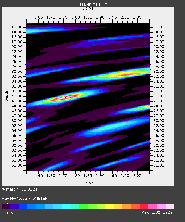
| Estimated Moho Depth: |
40.25 km |
| Estimated Crust Vp/Vs: |
1.76 |
| Assumed Crust Vp: |
6.194 km/s |
| Estimated Crust Vs: |
3.524 km/s |
| Estimated Crust Poisson's Ratio: |
0.26 |
|
| Radial Match: |
88.8124 % |
| Radial Bump: |
344 |
| Transverse Match: |
85.45139 % |
| Transverse Bump: |
351 |
| SOD ConfigId: |
1085051 |
| Insert Time: |
2015-08-12 00:34:53.438 +0000 |
| GWidth: |
2.5 |
| Max Bumps: |
400 |
| Tol: |
0.001 |
|
Signal To Noise
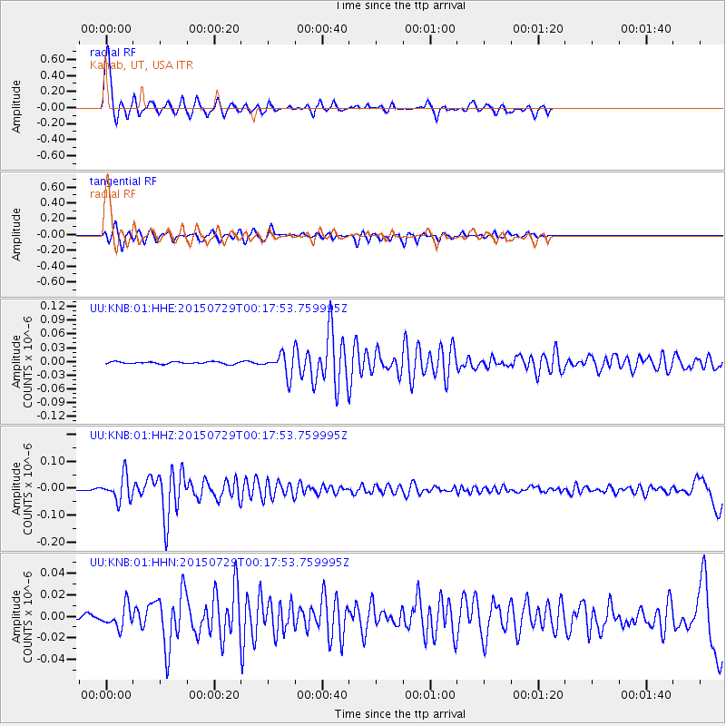
| Channel | StoN | STA | LTA |
| UU:KNB:01:HHZ:20150729T00:17:53.759995Z | 17.548252 | 4.6812936E-8 | 2.6676692E-9 |
| UU:KNB:01:HHN:20150729T00:17:53.759995Z | 2.6067276 | 1.0318237E-8 | 3.95831E-9 |
| UU:KNB:01:HHE:20150729T00:17:53.759995Z | 10.541025 | 2.4213842E-8 | 2.297105E-9 |
| Arrivals |
| Ps | 5.2 SECOND |
| PpPs | 17 SECOND |
| PsPs/PpSs | 22 SECOND |


