You are here: Home > Network List > US - United States National Seismic Network Stations List
> Station DGMT Dagmar, Montana, USA > Earthquake Result Viewer
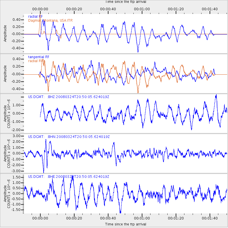
DGMT Dagmar, Montana, USA - Earthquake Result Viewer
*The percent match for this event was below the threshold and hence no stack was calculated.
| Earthquake location: |
Chile-Bolivia Border Region |
| Earthquake latitude/longitude: |
-20.0/-69.0 |
| Earthquake time(UTC): |
2008/03/24 (084) 20:39:07 GMT |
| Earthquake Depth: |
120 km |
| Earthquake Magnitude: |
5.7 MB, 6.2 MW, 6.1 MW |
| Earthquake Catalog/Contributor: |
WHDF/NEIC |
|
| Network: |
US United States National Seismic Network |
| Station: |
DGMT Dagmar, Montana, USA |
| Lat/Lon: |
48.47 N/104.20 W |
| Elevation: |
0.0 m |
|
| Distance: |
75.1 deg |
| Az: |
336.594 deg |
| Baz: |
145.862 deg |
| Ray Param: |
$rayparam |
*The percent match for this event was below the threshold and hence was not used in the summary stack. |
|
| Radial Match: |
62.47035 % |
| Radial Bump: |
400 |
| Transverse Match: |
62.194256 % |
| Transverse Bump: |
400 |
| SOD ConfigId: |
2504 |
| Insert Time: |
2010-03-05 01:28:00.884 +0000 |
| GWidth: |
2.5 |
| Max Bumps: |
400 |
| Tol: |
0.001 |
|
Signal To Noise
| Channel | StoN | STA | LTA |
| US:DGMT: :BHN:20080324T20:50:05.624019Z | 5.786799 | 1.3096989E-6 | 2.2632528E-7 |
| US:DGMT: :BHE:20080324T20:50:05.624019Z | 0.5206886 | 2.4864994E-7 | 4.775406E-7 |
| US:DGMT: :BHZ:20080324T20:50:05.624019Z | 1.0094218 | 5.178564E-7 | 5.1302277E-7 |
| Arrivals |
| Ps | |
| PpPs | |
| PsPs/PpSs | |


