You are here: Home > Network List > US - United States National Seismic Network Stations List
> Station DGMT Dagmar, Montana, USA > Earthquake Result Viewer
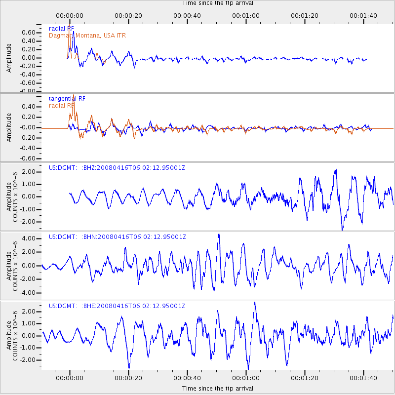
DGMT Dagmar, Montana, USA - Earthquake Result Viewer
*The percent match for this event was below the threshold and hence no stack was calculated.
| Earthquake location: |
Andreanof Islands, Aleutian Is. |
| Earthquake latitude/longitude: |
51.9/-179.2 |
| Earthquake time(UTC): |
2008/04/16 (107) 05:54:19 GMT |
| Earthquake Depth: |
13 km |
| Earthquake Magnitude: |
6.1 MB, 6.5 MS, 6.6 MW, 6.6 MW |
| Earthquake Catalog/Contributor: |
WHDF/NEIC |
|
| Network: |
US United States National Seismic Network |
| Station: |
DGMT Dagmar, Montana, USA |
| Lat/Lon: |
48.47 N/104.20 W |
| Elevation: |
0.0 m |
|
| Distance: |
46.2 deg |
| Az: |
63.016 deg |
| Baz: |
303.894 deg |
| Ray Param: |
$rayparam |
*The percent match for this event was below the threshold and hence was not used in the summary stack. |
|
| Radial Match: |
84.14719 % |
| Radial Bump: |
299 |
| Transverse Match: |
60.00628 % |
| Transverse Bump: |
386 |
| SOD ConfigId: |
2504 |
| Insert Time: |
2010-03-05 01:28:09.524 +0000 |
| GWidth: |
2.5 |
| Max Bumps: |
400 |
| Tol: |
0.001 |
|
Signal To Noise
| Channel | StoN | STA | LTA |
| US:DGMT: :BHN:20080416T06:02:12.95001Z | 4.0724354 | 7.41197E-7 | 1.8200339E-7 |
| US:DGMT: :BHE:20080416T06:02:12.95001Z | 0.8867644 | 4.0433238E-7 | 4.559637E-7 |
| US:DGMT: :BHZ:20080416T06:02:12.95001Z | 1.0585276 | 3.9172716E-7 | 3.70068E-7 |
| Arrivals |
| Ps | |
| PpPs | |
| PsPs/PpSs | |


