You are here: Home > Network List > AK - Alaska Regional Network Stations List
> Station BWN Brown > Earthquake Result Viewer
BWN Brown - Earthquake Result Viewer
| Earthquake location: |
Off Coast Of Chiapas, Mexico |
| Earthquake latitude/longitude: |
13.5/-92.2 |
| Earthquake time(UTC): |
2016/04/15 (106) 14:11:29 GMT |
| Earthquake Depth: |
48 km |
| Earthquake Magnitude: |
6.2 MWP |
| Earthquake Catalog/Contributor: |
NEIC PDE/NEIC COMCAT |
|
| Network: |
AK Alaska Regional Network |
| Station: |
BWN Brown |
| Lat/Lon: |
64.17 N/149.30 W |
| Elevation: |
369 m |
|
| Distance: |
63.9 deg |
| Az: |
335.822 deg |
| Baz: |
114.546 deg |
| Ray Param: |
0.05914814 |
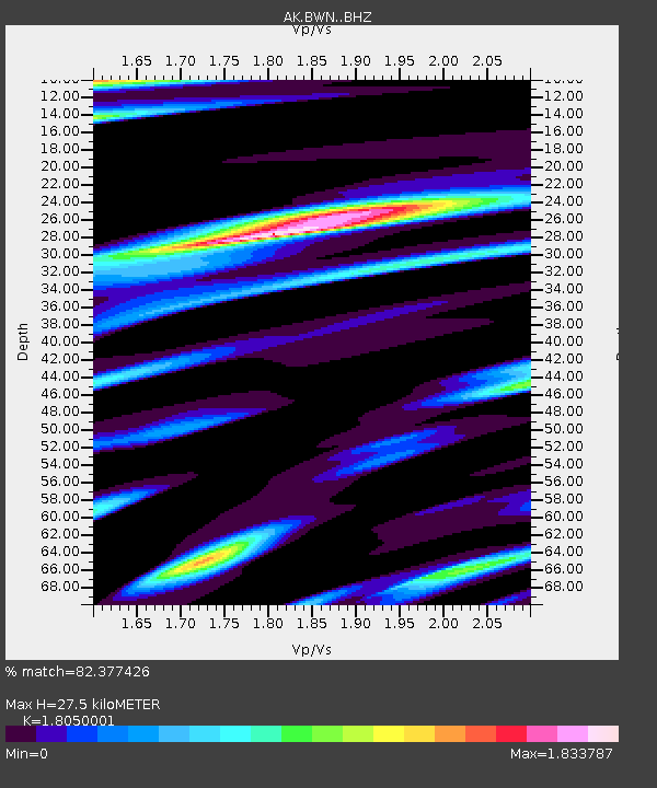
| Estimated Moho Depth: |
27.5 km |
| Estimated Crust Vp/Vs: |
1.81 |
| Assumed Crust Vp: |
6.566 km/s |
| Estimated Crust Vs: |
3.638 km/s |
| Estimated Crust Poisson's Ratio: |
0.28 |
|
| Radial Match: |
82.377426 % |
| Radial Bump: |
400 |
| Transverse Match: |
79.88813 % |
| Transverse Bump: |
400 |
| SOD ConfigId: |
7422571 |
| Insert Time: |
2019-04-22 06:55:03.388 +0000 |
| GWidth: |
2.5 |
| Max Bumps: |
400 |
| Tol: |
0.001 |
|

Signal To Noise
| Channel | StoN | STA | LTA |
| AK:BWN: :BHZ:20160415T14:21:26.488005Z | 17.488098 | 3.0457409E-6 | 1.7416079E-7 |
| AK:BWN: :BHN:20160415T14:21:26.488005Z | 2.1631267 | 6.518821E-7 | 3.01361E-7 |
| AK:BWN: :BHE:20160415T14:21:26.488005Z | 5.7228117 | 1.5489934E-6 | 2.7067E-7 |
| Arrivals |
| Ps | 3.5 SECOND |
| PpPs | 11 SECOND |
| PsPs/PpSs | 15 SECOND |


