You are here: Home > Network List > US - United States National Seismic Network Stations List
> Station DGMT Dagmar, Montana, USA > Earthquake Result Viewer
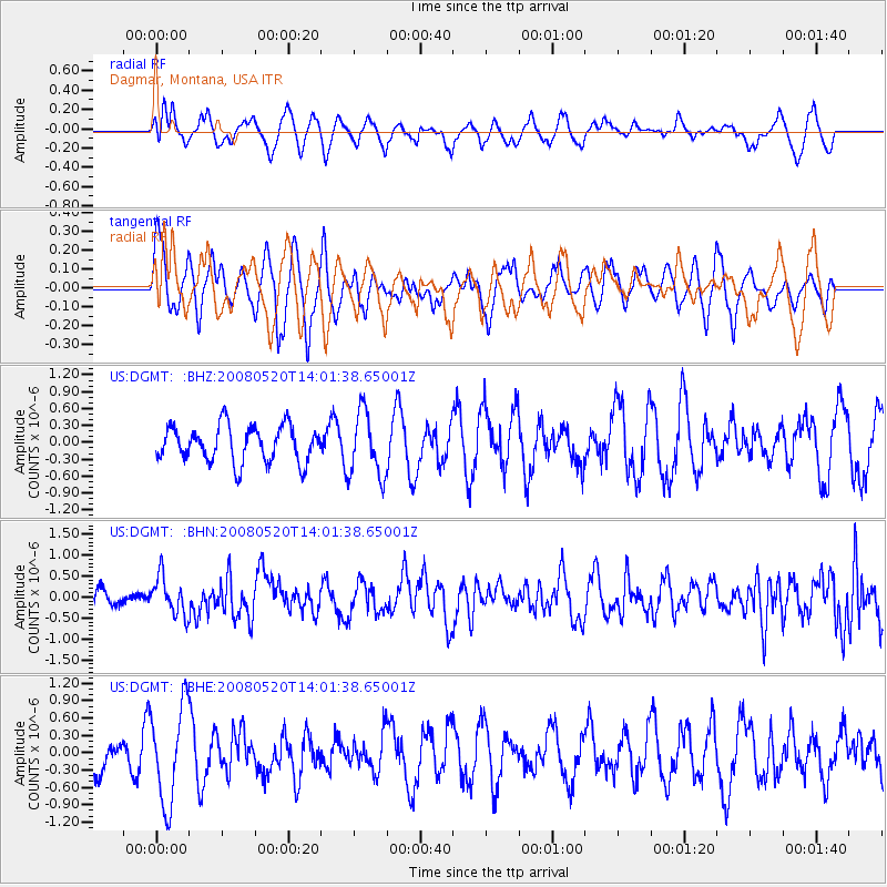
DGMT Dagmar, Montana, USA - Earthquake Result Viewer
*The percent match for this event was below the threshold and hence no stack was calculated.
| Earthquake location: |
Rat Islands, Aleutian Islands |
| Earthquake latitude/longitude: |
51.2/178.8 |
| Earthquake time(UTC): |
2008/05/20 (141) 13:53:35 GMT |
| Earthquake Depth: |
27 km |
| Earthquake Magnitude: |
5.8 MB, 6.0 MS, 6.3 MW, 6.3 MW |
| Earthquake Catalog/Contributor: |
WHDF/NEIC |
|
| Network: |
US United States National Seismic Network |
| Station: |
DGMT Dagmar, Montana, USA |
| Lat/Lon: |
48.47 N/104.20 W |
| Elevation: |
0.0 m |
|
| Distance: |
47.6 deg |
| Az: |
61.367 deg |
| Baz: |
303.854 deg |
| Ray Param: |
$rayparam |
*The percent match for this event was below the threshold and hence was not used in the summary stack. |
|
| Radial Match: |
74.249886 % |
| Radial Bump: |
400 |
| Transverse Match: |
59.49761 % |
| Transverse Bump: |
400 |
| SOD ConfigId: |
2504 |
| Insert Time: |
2010-03-05 01:28:21.161 +0000 |
| GWidth: |
2.5 |
| Max Bumps: |
400 |
| Tol: |
0.001 |
|
Signal To Noise
| Channel | StoN | STA | LTA |
| US:DGMT: :BHN:20080520T14:01:38.65001Z | 2.2658947 | 4.498411E-7 | 1.9852692E-7 |
| US:DGMT: :BHE:20080520T14:01:38.65001Z | 2.3378499 | 8.3688417E-7 | 3.5797171E-7 |
| US:DGMT: :BHZ:20080520T14:01:38.65001Z | 1.7817845 | 5.689381E-7 | 3.1930801E-7 |
| Arrivals |
| Ps | |
| PpPs | |
| PsPs/PpSs | |


