You are here: Home > Network List > CI - Caltech Regional Seismic Network Stations List
> Station BAR Barrett, Tecate, CA, USA > Earthquake Result Viewer
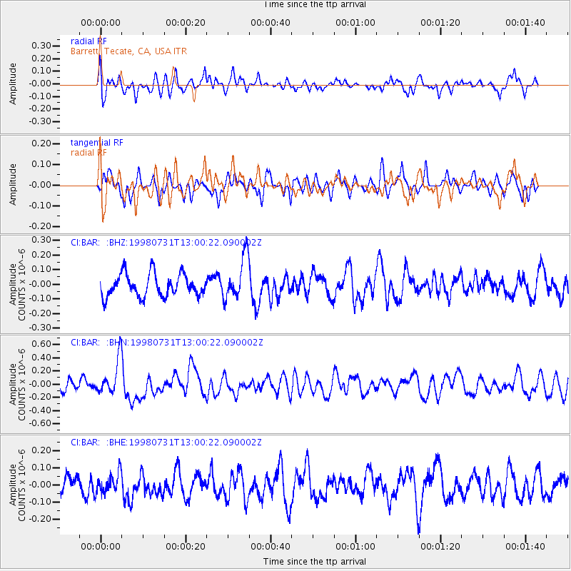
BAR Barrett, Tecate, CA, USA - Earthquake Result Viewer
*The percent match for this event was below the threshold and hence no stack was calculated.
| Earthquake location: |
Southeast Of Loyalty Islands |
| Earthquake latitude/longitude: |
-21.6/169.9 |
| Earthquake time(UTC): |
1998/07/31 (212) 12:48:04 GMT |
| Earthquake Depth: |
33 km |
| Earthquake Magnitude: |
5.5 MB, 5.3 MS, 5.8 UNKNOWN |
| Earthquake Catalog/Contributor: |
WHDF/NEIC |
|
| Network: |
CI Caltech Regional Seismic Network |
| Station: |
BAR Barrett, Tecate, CA, USA |
| Lat/Lon: |
32.68 N/116.67 W |
| Elevation: |
521 m |
|
| Distance: |
88.5 deg |
| Az: |
53.952 deg |
| Baz: |
243.117 deg |
| Ray Param: |
$rayparam |
*The percent match for this event was below the threshold and hence was not used in the summary stack. |
|
| Radial Match: |
59.832256 % |
| Radial Bump: |
400 |
| Transverse Match: |
56.9288 % |
| Transverse Bump: |
400 |
| SOD ConfigId: |
4480 |
| Insert Time: |
2010-02-26 00:14:28.942 +0000 |
| GWidth: |
2.5 |
| Max Bumps: |
400 |
| Tol: |
0.001 |
|
Signal To Noise
| Channel | StoN | STA | LTA |
| CI:BAR: :BHN:19980731T13:00:22.090002Z | 2.2186587 | 2.7394228E-7 | 1.2347202E-7 |
| CI:BAR: :BHE:19980731T13:00:22.090002Z | 0.7977212 | 5.448928E-8 | 6.830617E-8 |
| CI:BAR: :BHZ:19980731T13:00:22.090002Z | 1.9413033 | 1.4954732E-7 | 7.70345E-8 |
| Arrivals |
| Ps | |
| PpPs | |
| PsPs/PpSs | |


