You are here: Home > Network List > CI - Caltech Regional Seismic Network Stations List
> Station FMP Fort MacArthur Park, Pt. Fermin San Pedro, CA, USA > Earthquake Result Viewer
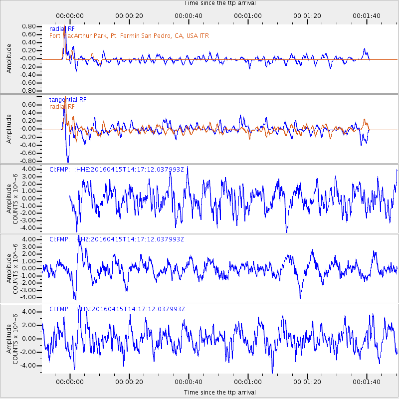
FMP Fort MacArthur Park, Pt. Fermin San Pedro, CA, USA - Earthquake Result Viewer
*The percent match for this event was below the threshold and hence no stack was calculated.
| Earthquake location: |
Off Coast Of Chiapas, Mexico |
| Earthquake latitude/longitude: |
13.5/-92.2 |
| Earthquake time(UTC): |
2016/04/15 (106) 14:11:29 GMT |
| Earthquake Depth: |
48 km |
| Earthquake Magnitude: |
6.2 MWP |
| Earthquake Catalog/Contributor: |
NEIC PDE/NEIC COMCAT |
|
| Network: |
CI Caltech Regional Seismic Network |
| Station: |
FMP Fort MacArthur Park, Pt. Fermin San Pedro, CA, USA |
| Lat/Lon: |
33.71 N/118.29 W |
| Elevation: |
89 m |
|
| Distance: |
31.1 deg |
| Az: |
314.769 deg |
| Baz: |
124.046 deg |
| Ray Param: |
$rayparam |
*The percent match for this event was below the threshold and hence was not used in the summary stack. |
|
| Radial Match: |
65.76277 % |
| Radial Bump: |
400 |
| Transverse Match: |
68.70409 % |
| Transverse Bump: |
400 |
| SOD ConfigId: |
7422571 |
| Insert Time: |
2019-04-22 06:57:17.962 +0000 |
| GWidth: |
2.5 |
| Max Bumps: |
400 |
| Tol: |
0.001 |
|
Signal To Noise
| Channel | StoN | STA | LTA |
| CI:FMP: :HHZ:20160415T14:17:12.037993Z | 4.618181 | 2.494653E-6 | 5.4018085E-7 |
| CI:FMP: :HHN:20160415T14:17:12.037993Z | 1.9236773 | 2.333126E-6 | 1.2128469E-6 |
| CI:FMP: :HHE:20160415T14:17:12.037993Z | 1.3019717 | 1.8335985E-6 | 1.4083245E-6 |
| Arrivals |
| Ps | |
| PpPs | |
| PsPs/PpSs | |


