You are here: Home > Network List > CI - Caltech Regional Seismic Network Stations List
> Station MPP McPhearson Peak > Earthquake Result Viewer
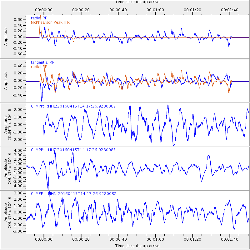
MPP McPhearson Peak - Earthquake Result Viewer
*The percent match for this event was below the threshold and hence no stack was calculated.
| Earthquake location: |
Off Coast Of Chiapas, Mexico |
| Earthquake latitude/longitude: |
13.5/-92.2 |
| Earthquake time(UTC): |
2016/04/15 (106) 14:11:29 GMT |
| Earthquake Depth: |
48 km |
| Earthquake Magnitude: |
6.2 MWP |
| Earthquake Catalog/Contributor: |
NEIC PDE/NEIC COMCAT |
|
| Network: |
CI Caltech Regional Seismic Network |
| Station: |
MPP McPhearson Peak |
| Lat/Lon: |
34.89 N/119.81 W |
| Elevation: |
1739 m |
|
| Distance: |
32.8 deg |
| Az: |
315.285 deg |
| Baz: |
123.632 deg |
| Ray Param: |
$rayparam |
*The percent match for this event was below the threshold and hence was not used in the summary stack. |
|
| Radial Match: |
51.81335 % |
| Radial Bump: |
400 |
| Transverse Match: |
58.346233 % |
| Transverse Bump: |
400 |
| SOD ConfigId: |
7422571 |
| Insert Time: |
2019-04-22 06:57:25.952 +0000 |
| GWidth: |
2.5 |
| Max Bumps: |
400 |
| Tol: |
0.001 |
|
Signal To Noise
| Channel | StoN | STA | LTA |
| CI:MPP: :HHZ:20160415T14:17:26.928008Z | 3.931557 | 1.9833105E-6 | 5.044593E-7 |
| CI:MPP: :HHN:20160415T14:17:26.928008Z | 1.9895647 | 1.6299144E-6 | 8.192317E-7 |
| CI:MPP: :HHE:20160415T14:17:26.928008Z | 0.965136 | 9.982997E-7 | 1.0343616E-6 |
| Arrivals |
| Ps | |
| PpPs | |
| PsPs/PpSs | |


