You are here: Home > Network List > US - United States National Seismic Network Stations List
> Station DGMT Dagmar, Montana, USA > Earthquake Result Viewer
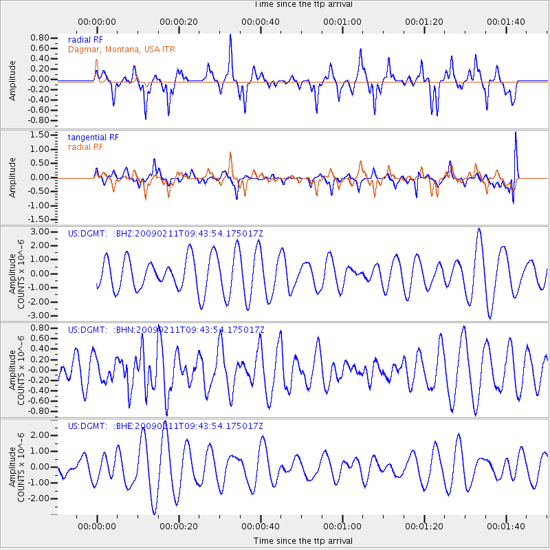
DGMT Dagmar, Montana, USA - Earthquake Result Viewer
*The percent match for this event was below the threshold and hence no stack was calculated.
| Earthquake location: |
Fiji Islands Region |
| Earthquake latitude/longitude: |
-20.8/-177.3 |
| Earthquake time(UTC): |
2009/02/11 (042) 09:31:04 GMT |
| Earthquake Depth: |
10 km |
| Earthquake Magnitude: |
5.5 MB, 5.2 MS, 5.5 MW, 5.5 MW |
| Earthquake Catalog/Contributor: |
WHDF/NEIC |
|
| Network: |
US United States National Seismic Network |
| Station: |
DGMT Dagmar, Montana, USA |
| Lat/Lon: |
48.47 N/104.20 W |
| Elevation: |
0.0 m |
|
| Distance: |
94.7 deg |
| Az: |
39.712 deg |
| Baz: |
243.949 deg |
| Ray Param: |
$rayparam |
*The percent match for this event was below the threshold and hence was not used in the summary stack. |
|
| Radial Match: |
51.53735 % |
| Radial Bump: |
325 |
| Transverse Match: |
40.993114 % |
| Transverse Bump: |
348 |
| SOD ConfigId: |
2658 |
| Insert Time: |
2010-03-05 01:28:51.968 +0000 |
| GWidth: |
2.5 |
| Max Bumps: |
400 |
| Tol: |
0.001 |
|
Signal To Noise
| Channel | StoN | STA | LTA |
| US:DGMT: :BHN:20090211T09:43:54.175017Z | 0.75863785 | 2.2060004E-7 | 2.9078439E-7 |
| US:DGMT: :BHE:20090211T09:43:54.175017Z | 1.3005028 | 7.4255786E-7 | 5.7097753E-7 |
| US:DGMT: :BHZ:20090211T09:43:54.175017Z | 1.6641558 | 1.6175236E-6 | 9.719784E-7 |
| Arrivals |
| Ps | |
| PpPs | |
| PsPs/PpSs | |


