You are here: Home > Network List > US - United States National Seismic Network Stations List
> Station DGMT Dagmar, Montana, USA > Earthquake Result Viewer
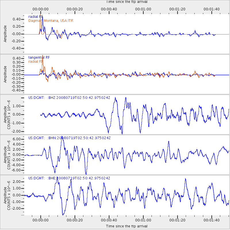
DGMT Dagmar, Montana, USA - Earthquake Result Viewer
*The percent match for this event was below the threshold and hence no stack was calculated.
| Earthquake location: |
Off East Coast Of Honshu, Japan |
| Earthquake latitude/longitude: |
37.6/142.2 |
| Earthquake time(UTC): |
2008/07/19 (201) 02:39:28 GMT |
| Earthquake Depth: |
22 km |
| Earthquake Magnitude: |
6.2 MB, 7.0 MS, 7.0 MW, 6.9 MW |
| Earthquake Catalog/Contributor: |
WHDF/NEIC |
|
| Network: |
US United States National Seismic Network |
| Station: |
DGMT Dagmar, Montana, USA |
| Lat/Lon: |
48.47 N/104.20 W |
| Elevation: |
0.0 m |
|
| Distance: |
76.0 deg |
| Az: |
38.936 deg |
| Baz: |
311.364 deg |
| Ray Param: |
$rayparam |
*The percent match for this event was below the threshold and hence was not used in the summary stack. |
|
| Radial Match: |
94.72927 % |
| Radial Bump: |
332 |
| Transverse Match: |
86.815285 % |
| Transverse Bump: |
400 |
| SOD ConfigId: |
2504 |
| Insert Time: |
2010-03-05 01:28:53.186 +0000 |
| GWidth: |
2.5 |
| Max Bumps: |
400 |
| Tol: |
0.001 |
|
Signal To Noise
| Channel | StoN | STA | LTA |
| US:DGMT: :BHN:20080719T02:50:42.975024Z | 12.496829 | 1.2451186E-6 | 9.963476E-8 |
| US:DGMT: :BHE:20080719T02:50:42.975024Z | 2.0985558 | 3.537566E-7 | 1.6857146E-7 |
| US:DGMT: :BHZ:20080719T02:50:42.975024Z | 2.3259132 | 3.6180475E-7 | 1.5555383E-7 |
| Arrivals |
| Ps | |
| PpPs | |
| PsPs/PpSs | |


