You are here: Home > Network List > US - United States National Seismic Network Stations List
> Station DGMT Dagmar, Montana, USA > Earthquake Result Viewer
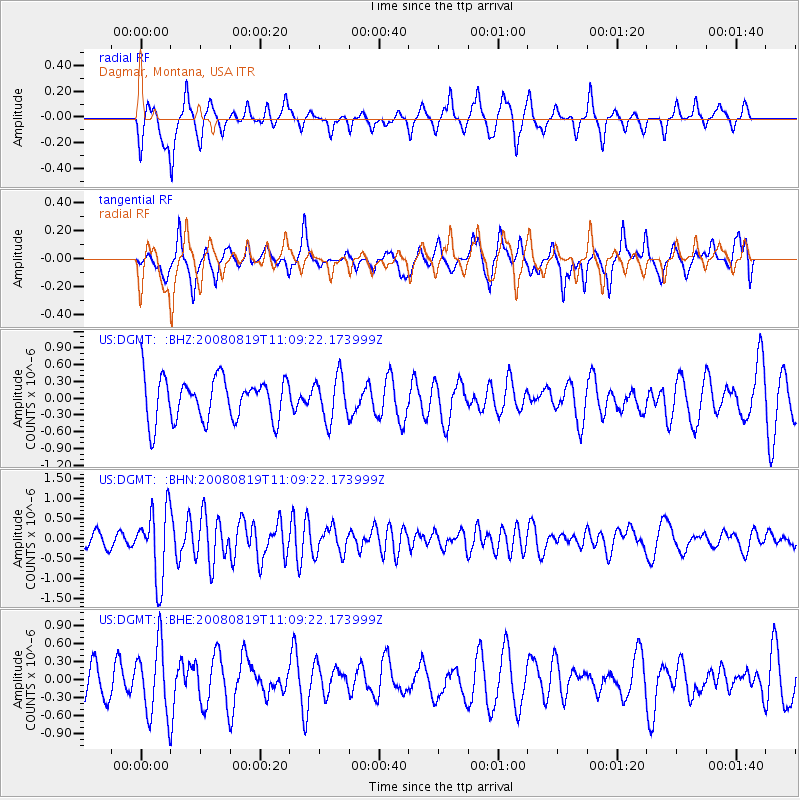
DGMT Dagmar, Montana, USA - Earthquake Result Viewer
*The percent match for this event was below the threshold and hence no stack was calculated.
| Earthquake location: |
Easter Island Region |
| Earthquake latitude/longitude: |
-28.5/-112.8 |
| Earthquake time(UTC): |
2008/08/19 (232) 10:58:00 GMT |
| Earthquake Depth: |
9.0 km |
| Earthquake Magnitude: |
5.5 MB, 5.3 MS, 5.7 MW, 5.7 MW |
| Earthquake Catalog/Contributor: |
WHDF/NEIC |
|
| Network: |
US United States National Seismic Network |
| Station: |
DGMT Dagmar, Montana, USA |
| Lat/Lon: |
48.47 N/104.20 W |
| Elevation: |
0.0 m |
|
| Distance: |
77.1 deg |
| Az: |
5.893 deg |
| Baz: |
187.8 deg |
| Ray Param: |
$rayparam |
*The percent match for this event was below the threshold and hence was not used in the summary stack. |
|
| Radial Match: |
58.948788 % |
| Radial Bump: |
365 |
| Transverse Match: |
66.63766 % |
| Transverse Bump: |
400 |
| SOD ConfigId: |
2504 |
| Insert Time: |
2010-03-05 01:29:02.111 +0000 |
| GWidth: |
2.5 |
| Max Bumps: |
400 |
| Tol: |
0.001 |
|
Signal To Noise
| Channel | StoN | STA | LTA |
| US:DGMT: :BHN:20080819T11:09:22.173999Z | 5.1078587 | 8.7797395E-7 | 1.718869E-7 |
| US:DGMT: :BHE:20080819T11:09:22.173999Z | 1.4528561 | 5.823465E-7 | 4.0082878E-7 |
| US:DGMT: :BHZ:20080819T11:09:22.173999Z | 1.038531 | 3.9434622E-7 | 3.7971543E-7 |
| Arrivals |
| Ps | |
| PpPs | |
| PsPs/PpSs | |


