You are here: Home > Network List > GT - Global Telemetered Seismograph Network (USAF/USGS) Stations List
> Station PLCA Paso Flores, Argentina > Earthquake Result Viewer
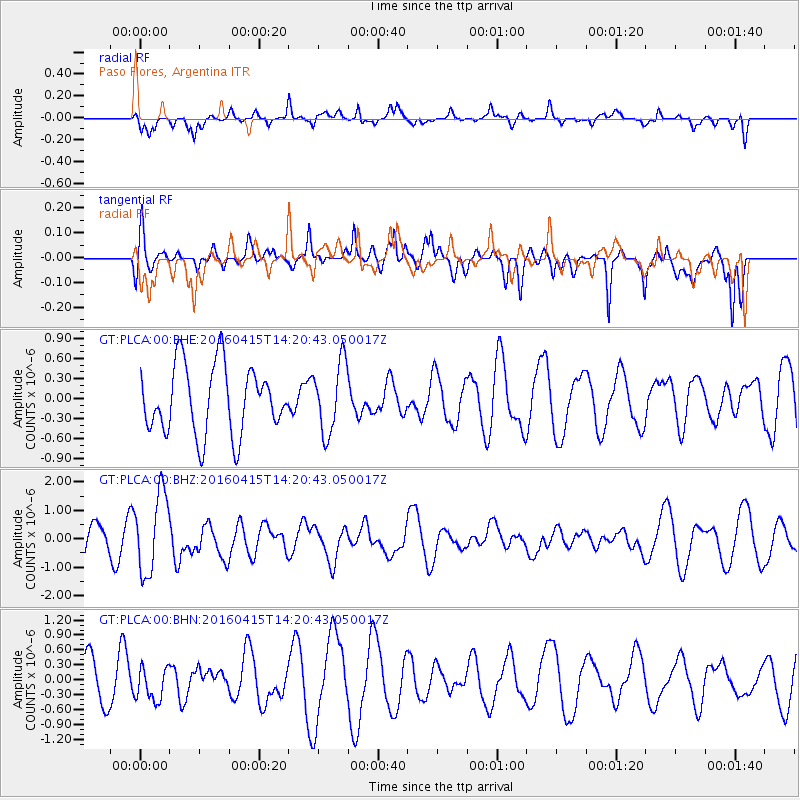
PLCA Paso Flores, Argentina - Earthquake Result Viewer
*The percent match for this event was below the threshold and hence no stack was calculated.
| Earthquake location: |
Off Coast Of Chiapas, Mexico |
| Earthquake latitude/longitude: |
13.5/-92.2 |
| Earthquake time(UTC): |
2016/04/15 (106) 14:11:29 GMT |
| Earthquake Depth: |
48 km |
| Earthquake Magnitude: |
6.2 MWP |
| Earthquake Catalog/Contributor: |
NEIC PDE/NEIC COMCAT |
|
| Network: |
GT Global Telemetered Seismograph Network (USAF/USGS) |
| Station: |
PLCA Paso Flores, Argentina |
| Lat/Lon: |
40.73 S/70.55 W |
| Elevation: |
1050 m |
|
| Distance: |
57.5 deg |
| Az: |
160.626 deg |
| Baz: |
334.87 deg |
| Ray Param: |
$rayparam |
*The percent match for this event was below the threshold and hence was not used in the summary stack. |
|
| Radial Match: |
35.404327 % |
| Radial Bump: |
299 |
| Transverse Match: |
67.081696 % |
| Transverse Bump: |
400 |
| SOD ConfigId: |
7422571 |
| Insert Time: |
2019-04-22 06:59:14.474 +0000 |
| GWidth: |
2.5 |
| Max Bumps: |
400 |
| Tol: |
0.001 |
|
Signal To Noise
| Channel | StoN | STA | LTA |
| GT:PLCA:00:BHZ:20160415T14:20:43.050017Z | 3.0544212 | 1.392516E-6 | 4.5590176E-7 |
| GT:PLCA:00:BHN:20160415T14:20:43.050017Z | 0.9614796 | 3.2759905E-7 | 3.407239E-7 |
| GT:PLCA:00:BHE:20160415T14:20:43.050017Z | 1.0293983 | 5.196815E-7 | 5.048401E-7 |
| Arrivals |
| Ps | |
| PpPs | |
| PsPs/PpSs | |


