You are here: Home > Network List > US - United States National Seismic Network Stations List
> Station DGMT Dagmar, Montana, USA > Earthquake Result Viewer
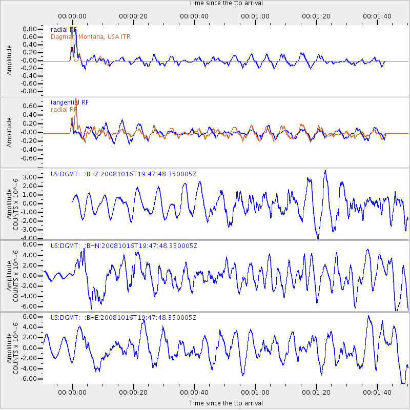
DGMT Dagmar, Montana, USA - Earthquake Result Viewer
*The percent match for this event was below the threshold and hence no stack was calculated.
| Earthquake location: |
Near Coast Of Chiapas, Mexico |
| Earthquake latitude/longitude: |
14.4/-92.4 |
| Earthquake time(UTC): |
2008/10/16 (290) 19:41:25 GMT |
| Earthquake Depth: |
24 km |
| Earthquake Magnitude: |
6.1 MB, 6.6 MS, 6.7 MW, 6.6 MW |
| Earthquake Catalog/Contributor: |
WHDF/NEIC |
|
| Network: |
US United States National Seismic Network |
| Station: |
DGMT Dagmar, Montana, USA |
| Lat/Lon: |
48.47 N/104.20 W |
| Elevation: |
0.0 m |
|
| Distance: |
35.3 deg |
| Az: |
346.352 deg |
| Baz: |
159.909 deg |
| Ray Param: |
$rayparam |
*The percent match for this event was below the threshold and hence was not used in the summary stack. |
|
| Radial Match: |
75.02388 % |
| Radial Bump: |
380 |
| Transverse Match: |
50.93802 % |
| Transverse Bump: |
400 |
| SOD ConfigId: |
2556 |
| Insert Time: |
2010-03-05 01:29:08.518 +0000 |
| GWidth: |
2.5 |
| Max Bumps: |
400 |
| Tol: |
0.001 |
|
Signal To Noise
| Channel | StoN | STA | LTA |
| US:DGMT: :BHN:20081016T19:47:48.350005Z | 5.662568 | 2.5792513E-6 | 4.5549143E-7 |
| US:DGMT: :BHE:20081016T19:47:48.350005Z | 1.5176365 | 2.5969475E-6 | 1.7111788E-6 |
| US:DGMT: :BHZ:20081016T19:47:48.350005Z | 1.0757289 | 1.0272762E-6 | 9.549583E-7 |
| Arrivals |
| Ps | |
| PpPs | |
| PsPs/PpSs | |


