You are here: Home > Network List > LD - Lamont-Doherty Cooperative Seismographic Network Stations List
> Station GEDE Greenville, DE, USA > Earthquake Result Viewer
GEDE Greenville, DE, USA - Earthquake Result Viewer
*The percent match for this event was below the threshold and hence no stack was calculated.
| Earthquake location: |
Off Coast Of Chiapas, Mexico |
| Earthquake latitude/longitude: |
13.5/-92.2 |
| Earthquake time(UTC): |
2016/04/15 (106) 14:11:29 GMT |
| Earthquake Depth: |
48 km |
| Earthquake Magnitude: |
6.2 MWP |
| Earthquake Catalog/Contributor: |
NEIC PDE/NEIC COMCAT |
|
| Network: |
LD Lamont-Doherty Cooperative Seismographic Network |
| Station: |
GEDE Greenville, DE, USA |
| Lat/Lon: |
39.81 N/75.64 W |
| Elevation: |
105 m |
|
| Distance: |
30.0 deg |
| Az: |
25.992 deg |
| Baz: |
213.607 deg |
| Ray Param: |
$rayparam |
*The percent match for this event was below the threshold and hence was not used in the summary stack. |
|
| Radial Match: |
74.42296 % |
| Radial Bump: |
398 |
| Transverse Match: |
58.085953 % |
| Transverse Bump: |
400 |
| SOD ConfigId: |
7422571 |
| Insert Time: |
2019-04-22 06:59:41.879 +0000 |
| GWidth: |
2.5 |
| Max Bumps: |
400 |
| Tol: |
0.001 |
|
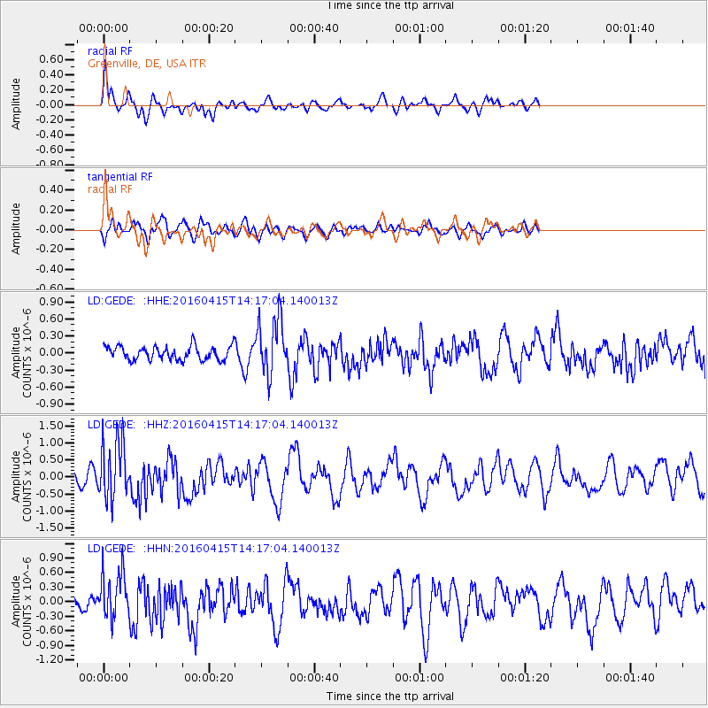
Signal To Noise
| Channel | StoN | STA | LTA |
| LD:GEDE: :HHZ:20160415T14:17:04.140013Z | 4.647783 | 8.821203E-7 | 1.8979378E-7 |
| LD:GEDE: :HHN:20160415T14:17:04.140013Z | 3.3423314 | 4.9277554E-7 | 1.4743466E-7 |
| LD:GEDE: :HHE:20160415T14:17:04.140013Z | 4.282321 | 5.0557617E-7 | 1.1806126E-7 |
| Arrivals |
| Ps | |
| PpPs | |
| PsPs/PpSs | |


