You are here: Home > Network List > US - United States National Seismic Network Stations List
> Station DGMT Dagmar, Montana, USA > Earthquake Result Viewer
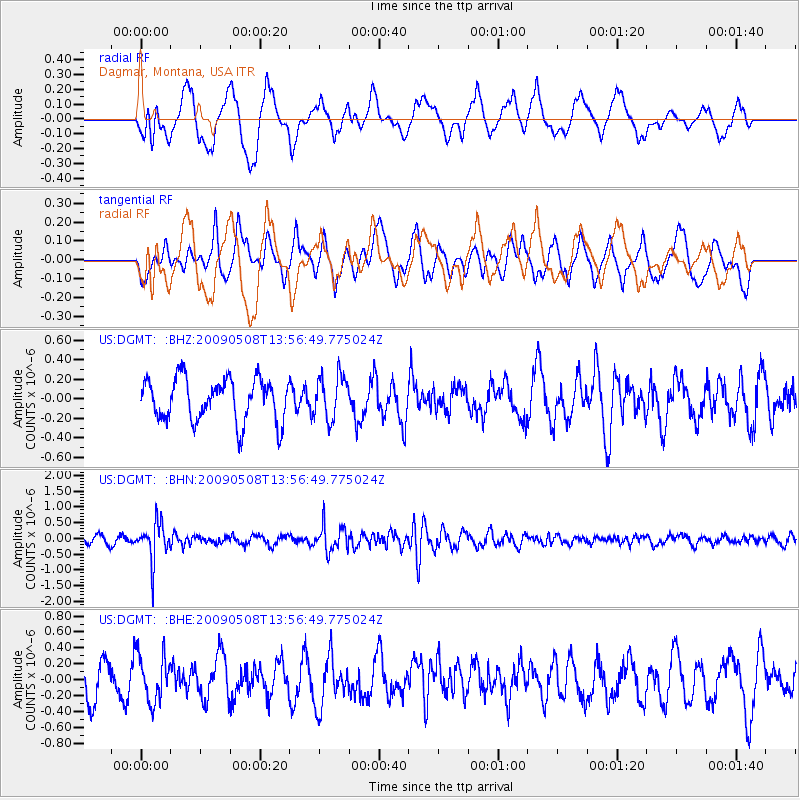
DGMT Dagmar, Montana, USA - Earthquake Result Viewer
*The percent match for this event was below the threshold and hence no stack was calculated.
| Earthquake location: |
Mendoza Province, Argentina |
| Earthquake latitude/longitude: |
-32.1/-69.7 |
| Earthquake time(UTC): |
2009/05/08 (128) 13:44:53 GMT |
| Earthquake Depth: |
112 km |
| Earthquake Magnitude: |
5.6 MB, 5.4 MW |
| Earthquake Catalog/Contributor: |
WHDF/NEIC |
|
| Network: |
US United States National Seismic Network |
| Station: |
DGMT Dagmar, Montana, USA |
| Lat/Lon: |
48.47 N/104.20 W |
| Elevation: |
0.0 m |
|
| Distance: |
85.9 deg |
| Az: |
337.786 deg |
| Baz: |
151.159 deg |
| Ray Param: |
$rayparam |
*The percent match for this event was below the threshold and hence was not used in the summary stack. |
|
| Radial Match: |
53.246212 % |
| Radial Bump: |
400 |
| Transverse Match: |
47.446 % |
| Transverse Bump: |
400 |
| SOD ConfigId: |
2658 |
| Insert Time: |
2010-03-05 01:29:13.225 +0000 |
| GWidth: |
2.5 |
| Max Bumps: |
400 |
| Tol: |
0.001 |
|
Signal To Noise
| Channel | StoN | STA | LTA |
| US:DGMT: :BHN:20090508T13:56:49.775024Z | 4.645397 | 6.014984E-7 | 1.2948266E-7 |
| US:DGMT: :BHE:20090508T13:56:49.775024Z | 1.3758341 | 2.9319298E-7 | 2.13102E-7 |
| US:DGMT: :BHZ:20090508T13:56:49.775024Z | 1.0178047 | 2.2202677E-7 | 2.1814277E-7 |
| Arrivals |
| Ps | |
| PpPs | |
| PsPs/PpSs | |


