You are here: Home > Network List > AG - Arkansas Seismic Network Stations List
> Station HHAR Hobbs,AR > Earthquake Result Viewer
HHAR Hobbs,AR - Earthquake Result Viewer
| Earthquake location: |
Southern Alaska |
| Earthquake latitude/longitude: |
59.9/-153.1 |
| Earthquake time(UTC): |
2015/07/29 (210) 02:35:58 GMT |
| Earthquake Depth: |
118 km |
| Earthquake Magnitude: |
6.3 ML, 6.2 MWP, 6.2 MI, 6.3 MWW |
| Earthquake Catalog/Contributor: |
NEIC PDE/NEIC COMCAT |
|
| Network: |
AG Arkansas Seismic Network |
| Station: |
HHAR Hobbs,AR |
| Lat/Lon: |
36.28 N/93.94 W |
| Elevation: |
421 m |
|
| Distance: |
44.1 deg |
| Az: |
95.03 deg |
| Baz: |
321.578 deg |
| Ray Param: |
0.07170482 |
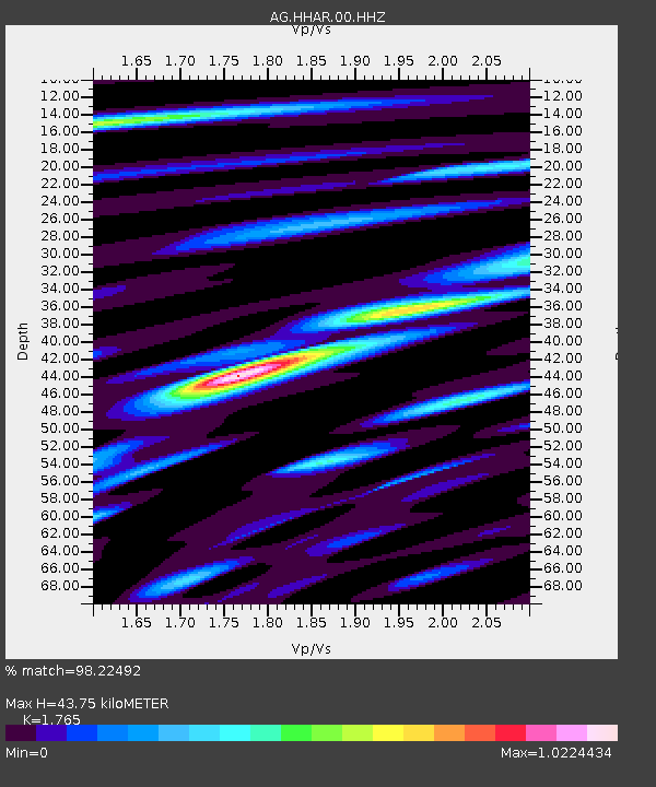
| Estimated Moho Depth: |
43.75 km |
| Estimated Crust Vp/Vs: |
1.76 |
| Assumed Crust Vp: |
6.53 km/s |
| Estimated Crust Vs: |
3.7 km/s |
| Estimated Crust Poisson's Ratio: |
0.26 |
|
| Radial Match: |
98.22492 % |
| Radial Bump: |
308 |
| Transverse Match: |
89.45699 % |
| Transverse Bump: |
400 |
| SOD ConfigId: |
1085051 |
| Insert Time: |
2015-08-12 02:55:10.690 +0000 |
| GWidth: |
2.5 |
| Max Bumps: |
400 |
| Tol: |
0.001 |
|

Signal To Noise
| Channel | StoN | STA | LTA |
| AG:HHAR:00:HHZ:20150729T02:43:24.204987Z | 9.599353 | 5.281773E-7 | 5.5022177E-8 |
| AG:HHAR:00:HHN:20150729T02:43:24.204987Z | 8.312317 | 2.2825962E-7 | 2.7460409E-8 |
| AG:HHAR:00:HHE:20150729T02:43:24.204987Z | 4.1962166 | 2.1598473E-7 | 5.1471304E-8 |
| Arrivals |
| Ps | 5.5 SECOND |
| PpPs | 17 SECOND |
| PsPs/PpSs | 23 SECOND |


