You are here: Home > Network List > US - United States National Seismic Network Stations List
> Station DGMT Dagmar, Montana, USA > Earthquake Result Viewer
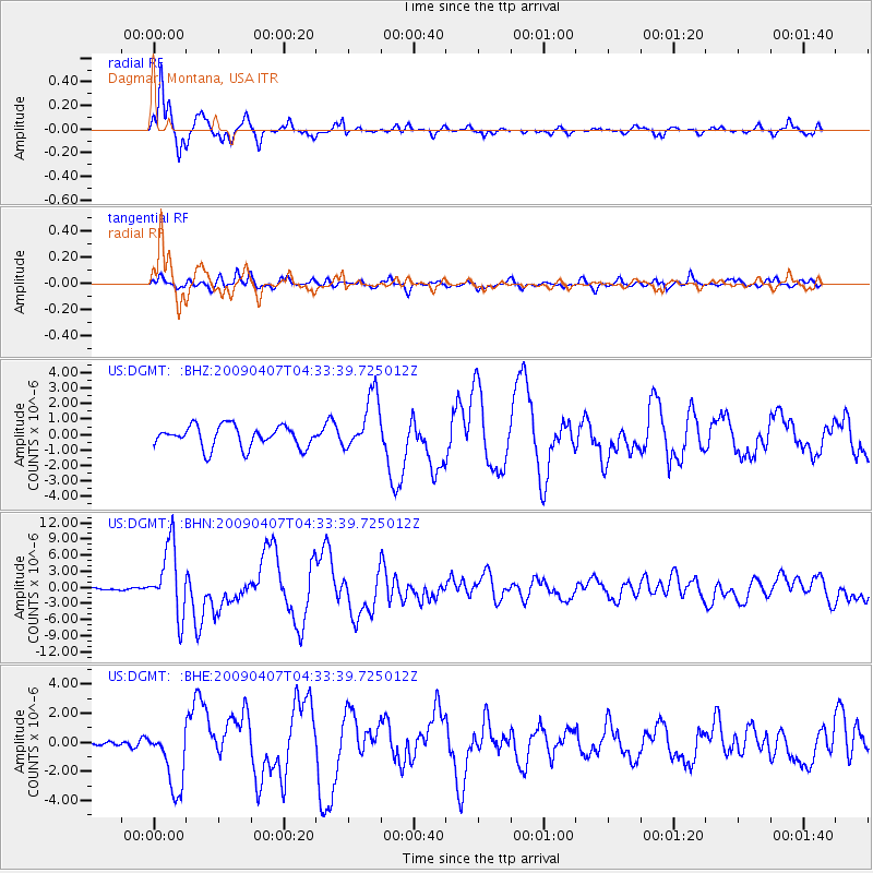
DGMT Dagmar, Montana, USA - Earthquake Result Viewer
*The percent match for this event was below the threshold and hence no stack was calculated.
| Earthquake location: |
Kuril Islands |
| Earthquake latitude/longitude: |
46.0/151.5 |
| Earthquake time(UTC): |
2009/04/07 (097) 04:23:33 GMT |
| Earthquake Depth: |
31 km |
| Earthquake Magnitude: |
6.5 MB, 6.8 MS, 6.9 MW, 6.9 MW |
| Earthquake Catalog/Contributor: |
WHDF/NEIC |
|
| Network: |
US United States National Seismic Network |
| Station: |
DGMT Dagmar, Montana, USA |
| Lat/Lon: |
48.47 N/104.20 W |
| Elevation: |
0.0 m |
|
| Distance: |
65.1 deg |
| Az: |
45.338 deg |
| Baz: |
311.897 deg |
| Ray Param: |
$rayparam |
*The percent match for this event was below the threshold and hence was not used in the summary stack. |
|
| Radial Match: |
90.3769 % |
| Radial Bump: |
277 |
| Transverse Match: |
81.196915 % |
| Transverse Bump: |
400 |
| SOD ConfigId: |
2658 |
| Insert Time: |
2010-03-05 01:29:17.565 +0000 |
| GWidth: |
2.5 |
| Max Bumps: |
400 |
| Tol: |
0.001 |
|
Signal To Noise
| Channel | StoN | STA | LTA |
| US:DGMT: :BHN:20090407T04:33:39.725012Z | 28.51115 | 6.428661E-6 | 2.2547884E-7 |
| US:DGMT: :BHE:20090407T04:33:39.725012Z | 6.540582 | 2.2441982E-6 | 3.4311904E-7 |
| US:DGMT: :BHZ:20090407T04:33:39.725012Z | 2.597641 | 1.8099054E-6 | 6.967496E-7 |
| Arrivals |
| Ps | |
| PpPs | |
| PsPs/PpSs | |


