You are here: Home > Network List > US - United States National Seismic Network Stations List
> Station DGMT Dagmar, Montana, USA > Earthquake Result Viewer
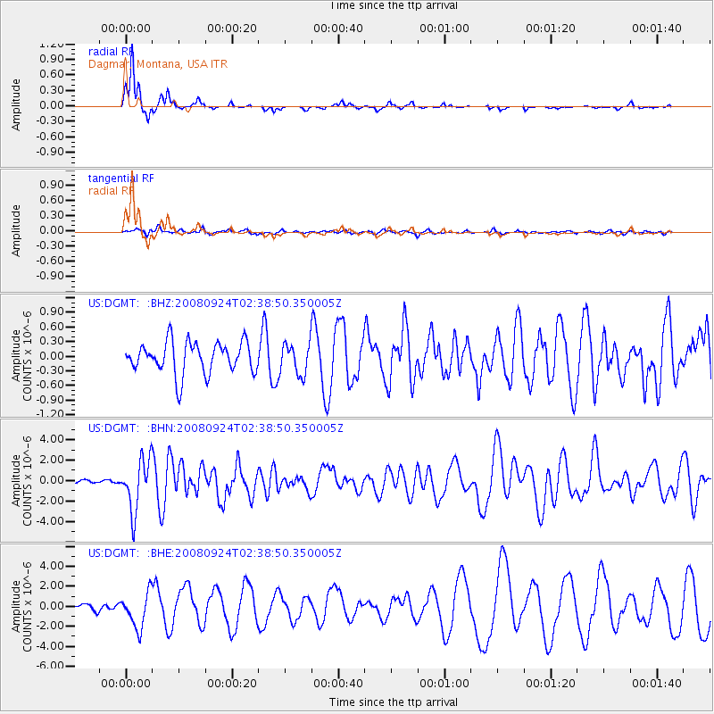
DGMT Dagmar, Montana, USA - Earthquake Result Viewer
*The percent match for this event was below the threshold and hence no stack was calculated.
| Earthquake location: |
Off Coast Of Jalisco, Mexico |
| Earthquake latitude/longitude: |
17.6/-105.5 |
| Earthquake time(UTC): |
2008/09/24 (268) 02:33:05 GMT |
| Earthquake Depth: |
10 km |
| Earthquake Magnitude: |
5.7 MB, 6.2 MS, 6.4 MW, 6.4 MW |
| Earthquake Catalog/Contributor: |
WHDF/NEIC |
|
| Network: |
US United States National Seismic Network |
| Station: |
DGMT Dagmar, Montana, USA |
| Lat/Lon: |
48.47 N/104.20 W |
| Elevation: |
0.0 m |
|
| Distance: |
30.8 deg |
| Az: |
1.696 deg |
| Baz: |
182.431 deg |
| Ray Param: |
$rayparam |
*The percent match for this event was below the threshold and hence was not used in the summary stack. |
|
| Radial Match: |
95.066376 % |
| Radial Bump: |
170 |
| Transverse Match: |
57.46293 % |
| Transverse Bump: |
351 |
| SOD ConfigId: |
2560 |
| Insert Time: |
2010-03-05 01:29:18.962 +0000 |
| GWidth: |
2.5 |
| Max Bumps: |
400 |
| Tol: |
0.001 |
|
Signal To Noise
| Channel | StoN | STA | LTA |
| US:DGMT: :BHN:20080924T02:38:50.350005Z | 19.824854 | 2.525845E-6 | 1.27408E-7 |
| US:DGMT: :BHE:20080924T02:38:50.350005Z | 5.779791 | 1.7682237E-6 | 3.0593213E-7 |
| US:DGMT: :BHZ:20080924T02:38:50.350005Z | 0.9728332 | 3.145205E-7 | 3.2330362E-7 |
| Arrivals |
| Ps | |
| PpPs | |
| PsPs/PpSs | |


