You are here: Home > Network List > US - United States National Seismic Network Stations List
> Station DGMT Dagmar, Montana, USA > Earthquake Result Viewer
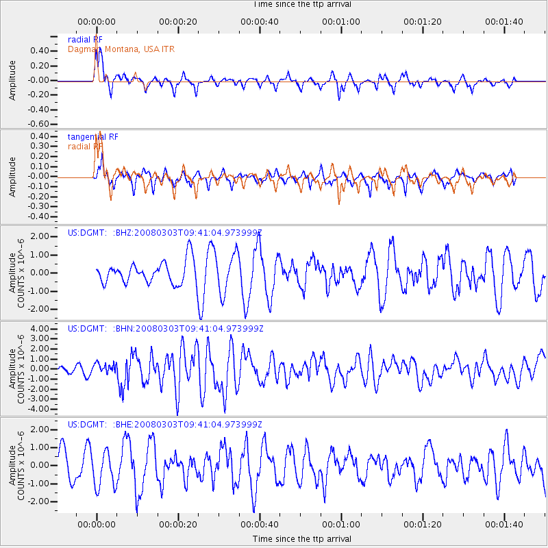
DGMT Dagmar, Montana, USA - Earthquake Result Viewer
*The percent match for this event was below the threshold and hence no stack was calculated.
| Earthquake location: |
Kuril Islands |
| Earthquake latitude/longitude: |
46.4/153.2 |
| Earthquake time(UTC): |
2008/03/03 (063) 09:31:02 GMT |
| Earthquake Depth: |
10 km |
| Earthquake Magnitude: |
6.2 MB, 6.5 MS, 6.5 MW, 6.5 MW |
| Earthquake Catalog/Contributor: |
WHDF/NEIC |
|
| Network: |
US United States National Seismic Network |
| Station: |
DGMT Dagmar, Montana, USA |
| Lat/Lon: |
48.47 N/104.20 W |
| Elevation: |
0.0 m |
|
| Distance: |
64.0 deg |
| Az: |
46.256 deg |
| Baz: |
311.308 deg |
| Ray Param: |
$rayparam |
*The percent match for this event was below the threshold and hence was not used in the summary stack. |
|
| Radial Match: |
64.157166 % |
| Radial Bump: |
400 |
| Transverse Match: |
50.534534 % |
| Transverse Bump: |
363 |
| SOD ConfigId: |
2504 |
| Insert Time: |
2010-03-05 01:29:32.848 +0000 |
| GWidth: |
2.5 |
| Max Bumps: |
400 |
| Tol: |
0.001 |
|
Signal To Noise
| Channel | StoN | STA | LTA |
| US:DGMT: :BHN:20080303T09:41:04.973999Z | 1.7019279 | 5.0794756E-7 | 2.984542E-7 |
| US:DGMT: :BHE:20080303T09:41:04.973999Z | 1.504588 | 9.839896E-7 | 6.5399274E-7 |
| US:DGMT: :BHZ:20080303T09:41:04.973999Z | 1.778032 | 1.0828695E-6 | 6.0902704E-7 |
| Arrivals |
| Ps | |
| PpPs | |
| PsPs/PpSs | |


