You are here: Home > Network List > US - United States National Seismic Network Stations List
> Station DGMT Dagmar, Montana, USA > Earthquake Result Viewer
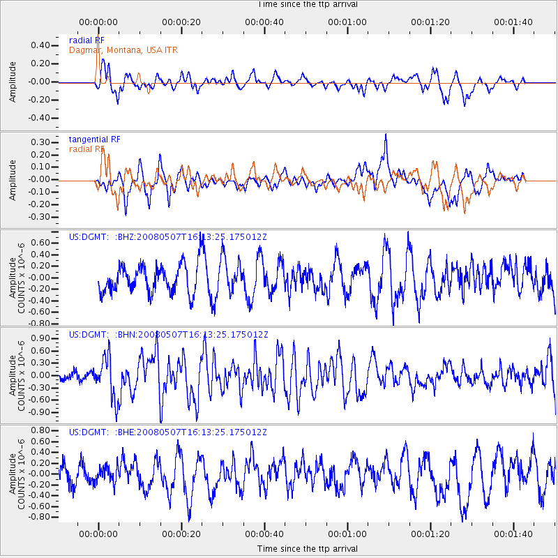
DGMT Dagmar, Montana, USA - Earthquake Result Viewer
*The percent match for this event was below the threshold and hence no stack was calculated.
| Earthquake location: |
Near East Coast Of Honshu, Japan |
| Earthquake latitude/longitude: |
36.2/141.5 |
| Earthquake time(UTC): |
2008/05/07 (128) 16:02:02 GMT |
| Earthquake Depth: |
19 km |
| Earthquake Magnitude: |
5.7 MB, 6.2 MW, 6.2 MW |
| Earthquake Catalog/Contributor: |
WHDF/NEIC |
|
| Network: |
US United States National Seismic Network |
| Station: |
DGMT Dagmar, Montana, USA |
| Lat/Lon: |
48.47 N/104.20 W |
| Elevation: |
0.0 m |
|
| Distance: |
77.4 deg |
| Az: |
38.433 deg |
| Baz: |
310.913 deg |
| Ray Param: |
$rayparam |
*The percent match for this event was below the threshold and hence was not used in the summary stack. |
|
| Radial Match: |
61.539543 % |
| Radial Bump: |
400 |
| Transverse Match: |
63.54762 % |
| Transverse Bump: |
400 |
| SOD ConfigId: |
2504 |
| Insert Time: |
2010-03-05 01:29:34.527 +0000 |
| GWidth: |
2.5 |
| Max Bumps: |
400 |
| Tol: |
0.001 |
|
Signal To Noise
| Channel | StoN | STA | LTA |
| US:DGMT: :BHN:20080507T16:13:25.175012Z | 5.0166593 | 5.140769E-7 | 1.0247395E-7 |
| US:DGMT: :BHE:20080507T16:13:25.175012Z | 0.67359984 | 1.4376944E-7 | 2.134345E-7 |
| US:DGMT: :BHZ:20080507T16:13:25.175012Z | 1.2060443 | 2.909989E-7 | 2.4128377E-7 |
| Arrivals |
| Ps | |
| PpPs | |
| PsPs/PpSs | |


