You are here: Home > Network List > US - United States National Seismic Network Stations List
> Station DGMT Dagmar, Montana, USA > Earthquake Result Viewer
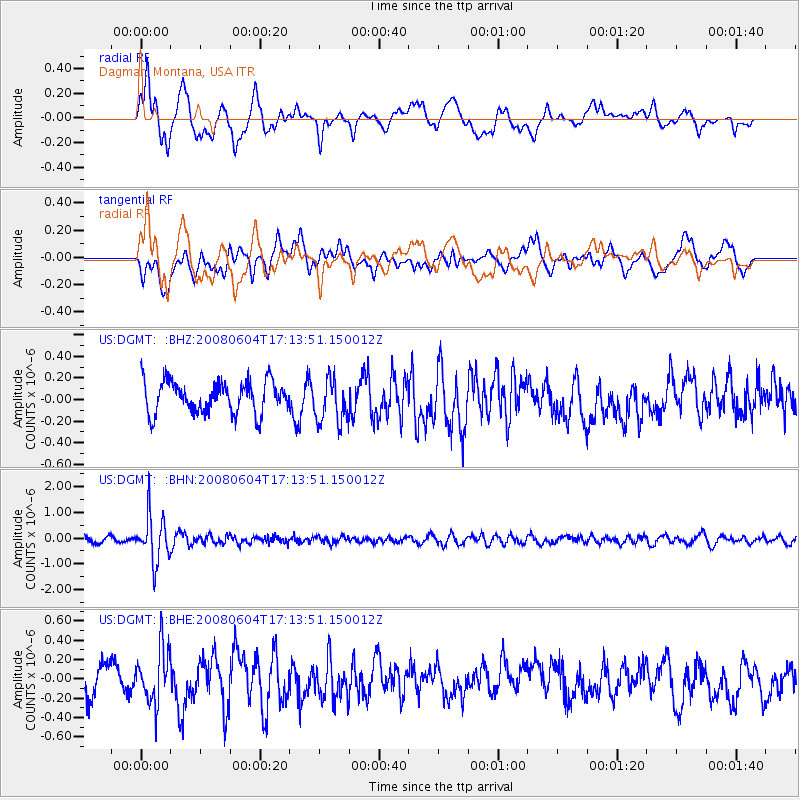
DGMT Dagmar, Montana, USA - Earthquake Result Viewer
*The percent match for this event was below the threshold and hence no stack was calculated.
| Earthquake location: |
Hokkaido, Japan Region |
| Earthquake latitude/longitude: |
41.5/139.0 |
| Earthquake time(UTC): |
2008/06/04 (156) 17:03:07 GMT |
| Earthquake Depth: |
213 km |
| Earthquake Magnitude: |
5.5 MB, 5.7 MW, 5.7 MW |
| Earthquake Catalog/Contributor: |
WHDF/NEIC |
|
| Network: |
US United States National Seismic Network |
| Station: |
DGMT Dagmar, Montana, USA |
| Lat/Lon: |
48.47 N/104.20 W |
| Elevation: |
0.0 m |
|
| Distance: |
74.4 deg |
| Az: |
38.085 deg |
| Baz: |
315.905 deg |
| Ray Param: |
$rayparam |
*The percent match for this event was below the threshold and hence was not used in the summary stack. |
|
| Radial Match: |
65.2739 % |
| Radial Bump: |
400 |
| Transverse Match: |
50.98255 % |
| Transverse Bump: |
400 |
| SOD ConfigId: |
2504 |
| Insert Time: |
2010-03-05 01:29:40.427 +0000 |
| GWidth: |
2.5 |
| Max Bumps: |
400 |
| Tol: |
0.001 |
|
Signal To Noise
| Channel | StoN | STA | LTA |
| US:DGMT: :BHN:20080604T17:13:51.150012Z | 8.76109 | 8.9229945E-7 | 1.0184799E-7 |
| US:DGMT: :BHE:20080604T17:13:51.150012Z | 1.8688562 | 2.8307673E-7 | 1.5147059E-7 |
| US:DGMT: :BHZ:20080604T17:13:51.150012Z | 1.4130988 | 2.0689652E-7 | 1.4641336E-7 |
| Arrivals |
| Ps | |
| PpPs | |
| PsPs/PpSs | |


