You are here: Home > Network List > US - United States National Seismic Network Stations List
> Station DGMT Dagmar, Montana, USA > Earthquake Result Viewer
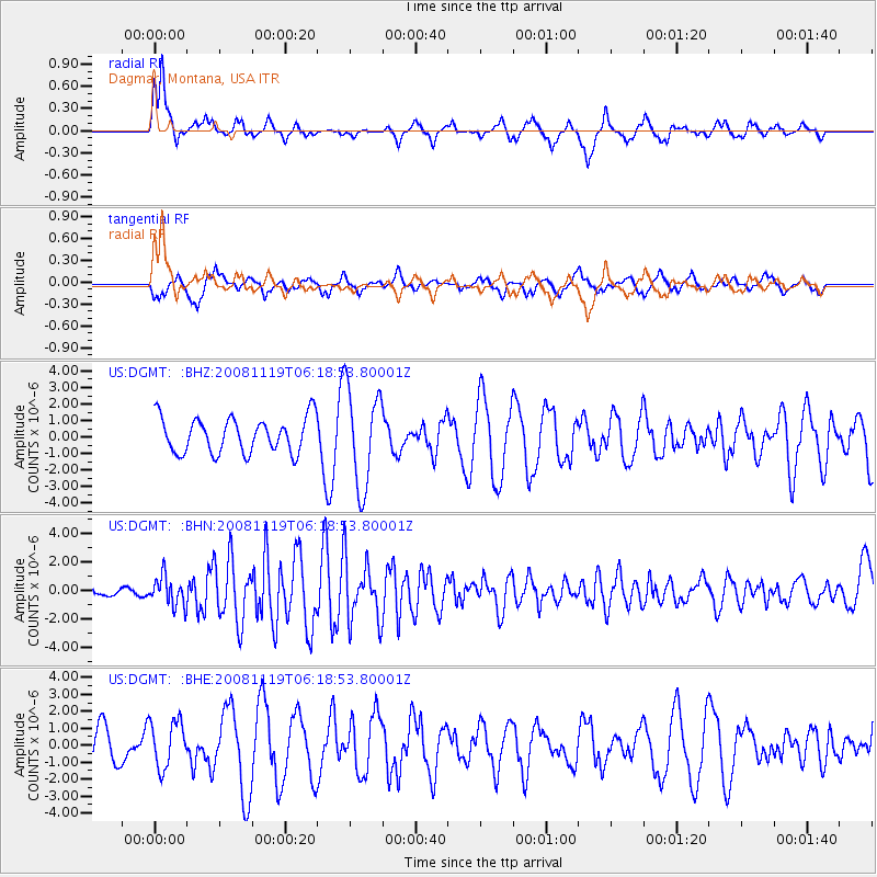
DGMT Dagmar, Montana, USA - Earthquake Result Viewer
*The percent match for this event was below the threshold and hence no stack was calculated.
| Earthquake location: |
Panama-Costa Rica Border Region |
| Earthquake latitude/longitude: |
8.3/-83.0 |
| Earthquake time(UTC): |
2008/11/19 (324) 06:11:20 GMT |
| Earthquake Depth: |
32 km |
| Earthquake Magnitude: |
5.9 MB, 5.9 MS, 6.2 MW, 6.1 MW |
| Earthquake Catalog/Contributor: |
WHDF/NEIC |
|
| Network: |
US United States National Seismic Network |
| Station: |
DGMT Dagmar, Montana, USA |
| Lat/Lon: |
48.47 N/104.20 W |
| Elevation: |
0.0 m |
|
| Distance: |
43.9 deg |
| Az: |
339.663 deg |
| Baz: |
148.878 deg |
| Ray Param: |
$rayparam |
*The percent match for this event was below the threshold and hence was not used in the summary stack. |
|
| Radial Match: |
66.638054 % |
| Radial Bump: |
365 |
| Transverse Match: |
50.22619 % |
| Transverse Bump: |
383 |
| SOD ConfigId: |
2658 |
| Insert Time: |
2010-03-05 01:29:46.506 +0000 |
| GWidth: |
2.5 |
| Max Bumps: |
400 |
| Tol: |
0.001 |
|
Signal To Noise
| Channel | StoN | STA | LTA |
| US:DGMT: :BHN:20081119T06:18:53.80001Z | 1.8698448 | 1.0068029E-6 | 5.3844195E-7 |
| US:DGMT: :BHE:20081119T06:18:53.80001Z | 1.4534307 | 1.3854818E-6 | 9.5324936E-7 |
| US:DGMT: :BHZ:20081119T06:18:53.80001Z | 2.809244 | 2.9853477E-6 | 1.0626873E-6 |
| Arrivals |
| Ps | |
| PpPs | |
| PsPs/PpSs | |


