You are here: Home > Network List > TA - USArray Transportable Network (new EarthScope stations) Stations List
> Station C06D Leavenworth, WQ, USA > Earthquake Result Viewer
C06D Leavenworth, WQ, USA - Earthquake Result Viewer
| Earthquake location: |
Off Coast Of Chiapas, Mexico |
| Earthquake latitude/longitude: |
13.5/-92.2 |
| Earthquake time(UTC): |
2016/04/15 (106) 14:11:29 GMT |
| Earthquake Depth: |
48 km |
| Earthquake Magnitude: |
6.2 MWP |
| Earthquake Catalog/Contributor: |
NEIC PDE/NEIC COMCAT |
|
| Network: |
TA USArray Transportable Network (new EarthScope stations) |
| Station: |
C06D Leavenworth, WQ, USA |
| Lat/Lon: |
47.92 N/120.89 W |
| Elevation: |
544 m |
|
| Distance: |
41.8 deg |
| Az: |
331.001 deg |
| Baz: |
135.479 deg |
| Ray Param: |
0.0734102 |
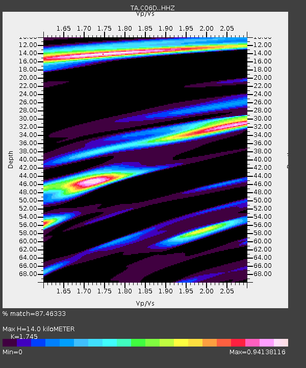
| Estimated Moho Depth: |
14.0 km |
| Estimated Crust Vp/Vs: |
1.75 |
| Assumed Crust Vp: |
6.597 km/s |
| Estimated Crust Vs: |
3.781 km/s |
| Estimated Crust Poisson's Ratio: |
0.26 |
|
| Radial Match: |
87.46333 % |
| Radial Bump: |
237 |
| Transverse Match: |
67.15475 % |
| Transverse Bump: |
400 |
| SOD ConfigId: |
7422571 |
| Insert Time: |
2019-04-22 07:02:14.005 +0000 |
| GWidth: |
2.5 |
| Max Bumps: |
400 |
| Tol: |
0.001 |
|
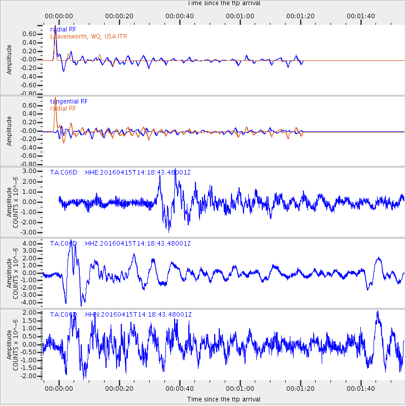
Signal To Noise
| Channel | StoN | STA | LTA |
| TA:C06D: :HHZ:20160415T14:18:43.48001Z | 7.799751 | 2.257798E-6 | 2.8947053E-7 |
| TA:C06D: :HHN:20160415T14:18:43.48001Z | 3.5155509 | 9.2976893E-7 | 2.644732E-7 |
| TA:C06D: :HHE:20160415T14:18:43.48001Z | 4.1560397 | 1.0974768E-6 | 2.6406792E-7 |
| Arrivals |
| Ps | 1.7 SECOND |
| PpPs | 5.4 SECOND |
| PsPs/PpSs | 7.1 SECOND |


