You are here: Home > Network List > TA - USArray Transportable Network (new EarthScope stations) Stations List
> Station J26L Joseph Creek, AK, USA > Earthquake Result Viewer
J26L Joseph Creek, AK, USA - Earthquake Result Viewer
| Earthquake location: |
Off Coast Of Chiapas, Mexico |
| Earthquake latitude/longitude: |
13.5/-92.2 |
| Earthquake time(UTC): |
2016/04/15 (106) 14:11:29 GMT |
| Earthquake Depth: |
48 km |
| Earthquake Magnitude: |
6.2 MWP |
| Earthquake Catalog/Contributor: |
NEIC PDE/NEIC COMCAT |
|
| Network: |
TA USArray Transportable Network (new EarthScope stations) |
| Station: |
J26L Joseph Creek, AK, USA |
| Lat/Lon: |
64.50 N/143.56 W |
| Elevation: |
1144 m |
|
| Distance: |
61.9 deg |
| Az: |
337.444 deg |
| Baz: |
120.446 deg |
| Ray Param: |
0.06049433 |
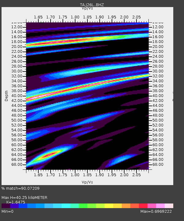
| Estimated Moho Depth: |
40.25 km |
| Estimated Crust Vp/Vs: |
1.65 |
| Assumed Crust Vp: |
6.566 km/s |
| Estimated Crust Vs: |
3.986 km/s |
| Estimated Crust Poisson's Ratio: |
0.21 |
|
| Radial Match: |
90.07209 % |
| Radial Bump: |
400 |
| Transverse Match: |
80.68661 % |
| Transverse Bump: |
400 |
| SOD ConfigId: |
7422571 |
| Insert Time: |
2019-04-22 07:02:38.993 +0000 |
| GWidth: |
2.5 |
| Max Bumps: |
400 |
| Tol: |
0.001 |
|

Signal To Noise
| Channel | StoN | STA | LTA |
| TA:J26L: :BHZ:20160415T14:21:12.82498Z | 20.706413 | 1.7412461E-6 | 8.4092115E-8 |
| TA:J26L: :BHN:20160415T14:21:12.82498Z | 2.019144 | 1.8827433E-7 | 9.324462E-8 |
| TA:J26L: :BHE:20160415T14:21:12.82498Z | 5.8581915 | 6.1645613E-7 | 1.05229766E-7 |
| Arrivals |
| Ps | 4.2 SECOND |
| PpPs | 15 SECOND |
| PsPs/PpSs | 20 SECOND |


