You are here: Home > Network List > US - United States National Seismic Network Stations List
> Station DGMT Dagmar, Montana, USA > Earthquake Result Viewer
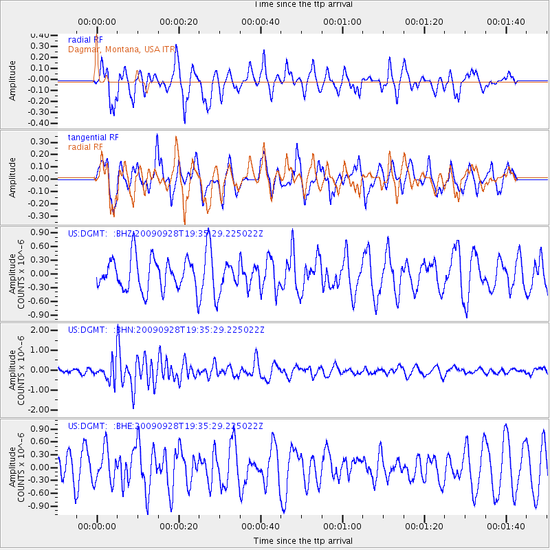
DGMT Dagmar, Montana, USA - Earthquake Result Viewer
*The percent match for this event was below the threshold and hence no stack was calculated.
| Earthquake location: |
Ryukyu Islands, Japan |
| Earthquake latitude/longitude: |
27.9/127.8 |
| Earthquake time(UTC): |
2009/09/28 (271) 19:22:57 GMT |
| Earthquake Depth: |
9.0 km |
| Earthquake Magnitude: |
5.7 MB, 5.6 MS, 5.8 MW, 5.8 MW |
| Earthquake Catalog/Contributor: |
WHDF/NEIC |
|
| Network: |
US United States National Seismic Network |
| Station: |
DGMT Dagmar, Montana, USA |
| Lat/Lon: |
48.47 N/104.20 W |
| Elevation: |
0.0 m |
|
| Distance: |
90.8 deg |
| Az: |
31.641 deg |
| Baz: |
315.774 deg |
| Ray Param: |
$rayparam |
*The percent match for this event was below the threshold and hence was not used in the summary stack. |
|
| Radial Match: |
51.478695 % |
| Radial Bump: |
303 |
| Transverse Match: |
59.63348 % |
| Transverse Bump: |
362 |
| SOD ConfigId: |
2622 |
| Insert Time: |
2010-03-05 01:30:22.174 +0000 |
| GWidth: |
2.5 |
| Max Bumps: |
400 |
| Tol: |
0.001 |
|
Signal To Noise
| Channel | StoN | STA | LTA |
| US:DGMT: :BHN:20090928T19:35:29.225022Z | 2.7415125 | 4.9267896E-7 | 1.7971064E-7 |
| US:DGMT: :BHE:20090928T19:35:29.225022Z | 1.2304361 | 4.0495735E-7 | 3.2911692E-7 |
| US:DGMT: :BHZ:20090928T19:35:29.225022Z | 0.9703572 | 3.3687988E-7 | 3.47171E-7 |
| Arrivals |
| Ps | |
| PpPs | |
| PsPs/PpSs | |


