You are here: Home > Network List > UW - Pacific Northwest Regional Seismic Network Stations List
> Station UMAT Pilot Rock, OR, USA > Earthquake Result Viewer
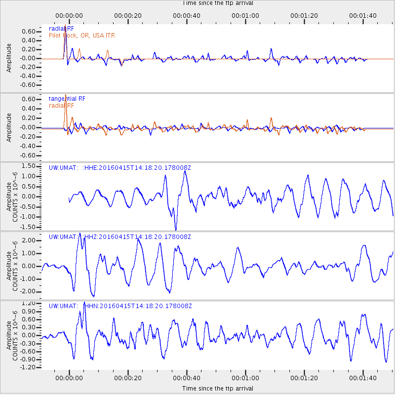
UMAT Pilot Rock, OR, USA - Earthquake Result Viewer
*The percent match for this event was below the threshold and hence no stack was calculated.
| Earthquake location: |
Off Coast Of Chiapas, Mexico |
| Earthquake latitude/longitude: |
13.5/-92.2 |
| Earthquake time(UTC): |
2016/04/15 (106) 14:11:29 GMT |
| Earthquake Depth: |
48 km |
| Earthquake Magnitude: |
6.2 MWP |
| Earthquake Catalog/Contributor: |
NEIC PDE/NEIC COMCAT |
|
| Network: |
UW Pacific Northwest Regional Seismic Network |
| Station: |
UMAT Pilot Rock, OR, USA |
| Lat/Lon: |
45.29 N/118.96 W |
| Elevation: |
1318 m |
|
| Distance: |
39.0 deg |
| Az: |
329.635 deg |
| Baz: |
135.84 deg |
| Ray Param: |
$rayparam |
*The percent match for this event was below the threshold and hence was not used in the summary stack. |
|
| Radial Match: |
83.39856 % |
| Radial Bump: |
400 |
| Transverse Match: |
87.135605 % |
| Transverse Bump: |
400 |
| SOD ConfigId: |
7422571 |
| Insert Time: |
2019-04-22 07:03:54.772 +0000 |
| GWidth: |
2.5 |
| Max Bumps: |
400 |
| Tol: |
0.001 |
|
Signal To Noise
| Channel | StoN | STA | LTA |
| UW:UMAT: :HHZ:20160415T14:18:20.178008Z | 4.664339 | 1.4549028E-6 | 3.1192045E-7 |
| UW:UMAT: :HHN:20160415T14:18:20.178008Z | 3.4129357 | 5.30827E-7 | 1.5553383E-7 |
| UW:UMAT: :HHE:20160415T14:18:20.178008Z | 2.481398 | 6.6034795E-7 | 2.6611932E-7 |
| Arrivals |
| Ps | |
| PpPs | |
| PsPs/PpSs | |


