You are here: Home > Network List > US - United States National Seismic Network Stations List
> Station DGMT Dagmar, Montana, USA > Earthquake Result Viewer
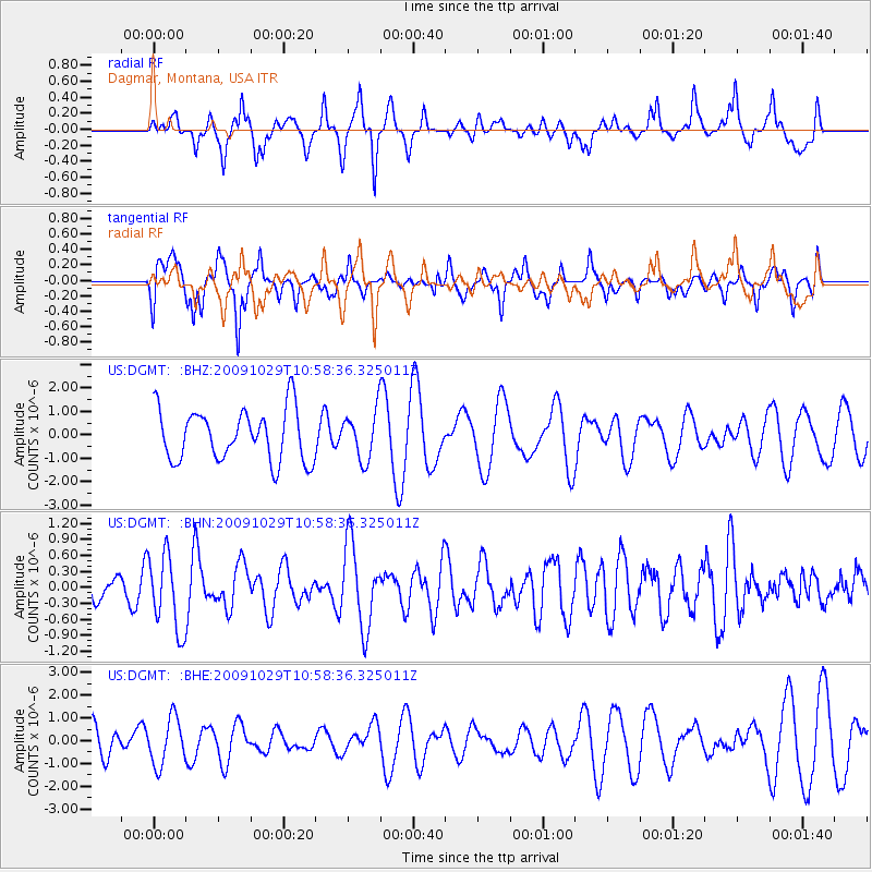
DGMT Dagmar, Montana, USA - Earthquake Result Viewer
*The percent match for this event was below the threshold and hence no stack was calculated.
| Earthquake location: |
Veracruz, Mexico |
| Earthquake latitude/longitude: |
18.9/-95.5 |
| Earthquake time(UTC): |
2009/10/29 (302) 10:52:56 GMT |
| Earthquake Depth: |
16 km |
| Earthquake Magnitude: |
5.5 MB, 5.3 MS, 5.7 MW, 5.5 MD |
| Earthquake Catalog/Contributor: |
WHDF/NEIC |
|
| Network: |
US United States National Seismic Network |
| Station: |
DGMT Dagmar, Montana, USA |
| Lat/Lon: |
48.47 N/104.20 W |
| Elevation: |
0.0 m |
|
| Distance: |
30.3 deg |
| Az: |
348.552 deg |
| Baz: |
163.6 deg |
| Ray Param: |
$rayparam |
*The percent match for this event was below the threshold and hence was not used in the summary stack. |
|
| Radial Match: |
69.26697 % |
| Radial Bump: |
353 |
| Transverse Match: |
55.645306 % |
| Transverse Bump: |
365 |
| SOD ConfigId: |
2622 |
| Insert Time: |
2010-03-05 01:30:34.575 +0000 |
| GWidth: |
2.5 |
| Max Bumps: |
400 |
| Tol: |
0.001 |
|
Signal To Noise
| Channel | StoN | STA | LTA |
| US:DGMT: :BHN:20091029T10:58:36.325011Z | 2.3893523 | 7.1245825E-7 | 2.9818048E-7 |
| US:DGMT: :BHE:20091029T10:58:36.325011Z | 0.95972437 | 1.028718E-6 | 1.071889E-6 |
| US:DGMT: :BHZ:20091029T10:58:36.325011Z | 0.9460393 | 1.0364618E-6 | 1.09558E-6 |
| Arrivals |
| Ps | |
| PpPs | |
| PsPs/PpSs | |


