You are here: Home > Network List > XD14 - Illuminating the architecture of the greater Mount St. Helens magmatic systems f Stations List
> Station MG10 "Mount St Helens, WA" > Earthquake Result Viewer
MG10 "Mount St Helens, WA" - Earthquake Result Viewer
| Earthquake location: |
Off Coast Of Chiapas, Mexico |
| Earthquake latitude/longitude: |
13.5/-92.2 |
| Earthquake time(UTC): |
2016/04/15 (106) 14:11:29 GMT |
| Earthquake Depth: |
48 km |
| Earthquake Magnitude: |
6.2 MWP |
| Earthquake Catalog/Contributor: |
NEIC PDE/NEIC COMCAT |
|
| Network: |
XD Illuminating the architecture of the greater Mount St. Helens magmatic systems f |
| Station: |
MG10 "Mount St Helens, WA" |
| Lat/Lon: |
46.34 N/121.66 W |
| Elevation: |
893 m |
|
| Distance: |
41.1 deg |
| Az: |
328.746 deg |
| Baz: |
133.23 deg |
| Ray Param: |
0.07387351 |
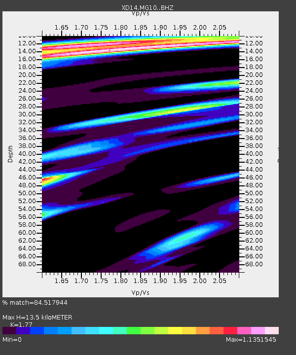
| Estimated Moho Depth: |
13.5 km |
| Estimated Crust Vp/Vs: |
1.77 |
| Assumed Crust Vp: |
6.597 km/s |
| Estimated Crust Vs: |
3.727 km/s |
| Estimated Crust Poisson's Ratio: |
0.27 |
|
| Radial Match: |
84.517944 % |
| Radial Bump: |
400 |
| Transverse Match: |
68.97473 % |
| Transverse Bump: |
400 |
| SOD ConfigId: |
7422571 |
| Insert Time: |
2019-04-22 07:04:36.739 +0000 |
| GWidth: |
2.5 |
| Max Bumps: |
400 |
| Tol: |
0.001 |
|

Signal To Noise
| Channel | StoN | STA | LTA |
| XD:MG10: :BHZ:20160415T14:18:37.420012Z | 7.700927 | 2.7599738E-6 | 3.5839503E-7 |
| XD:MG10: :BHN:20160415T14:18:37.420012Z | 2.6774628 | 7.645099E-7 | 2.855352E-7 |
| XD:MG10: :BHE:20160415T14:18:37.420012Z | 2.074612 | 7.306548E-7 | 3.521887E-7 |
| Arrivals |
| Ps | 1.7 SECOND |
| PpPs | 5.3 SECOND |
| PsPs/PpSs | 7.0 SECOND |


