You are here: Home > Network List > US - United States National Seismic Network Stations List
> Station DGMT Dagmar, Montana, USA > Earthquake Result Viewer
DGMT Dagmar, Montana, USA - Earthquake Result Viewer
*The percent match for this event was below the threshold and hence no stack was calculated.
| Earthquake location: |
Hokkaido, Japan Region |
| Earthquake latitude/longitude: |
42.6/142.1 |
| Earthquake time(UTC): |
2009/02/28 (059) 00:35:56 GMT |
| Earthquake Depth: |
105 km |
| Earthquake Magnitude: |
5.5 MB, 5.5 MW, 5.5 MW |
| Earthquake Catalog/Contributor: |
WHDF/NEIC |
|
| Network: |
US United States National Seismic Network |
| Station: |
DGMT Dagmar, Montana, USA |
| Lat/Lon: |
48.47 N/104.20 W |
| Elevation: |
0.0 m |
|
| Distance: |
72.2 deg |
| Az: |
39.797 deg |
| Baz: |
314.763 deg |
| Ray Param: |
$rayparam |
*The percent match for this event was below the threshold and hence was not used in the summary stack. |
|
| Radial Match: |
53.726543 % |
| Radial Bump: |
390 |
| Transverse Match: |
42.598473 % |
| Transverse Bump: |
400 |
| SOD ConfigId: |
2658 |
| Insert Time: |
2010-03-05 01:30:44.995 +0000 |
| GWidth: |
2.5 |
| Max Bumps: |
400 |
| Tol: |
0.001 |
|
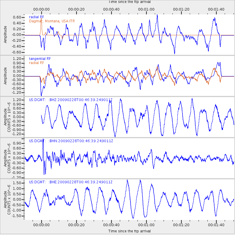
Signal To Noise
| Channel | StoN | STA | LTA |
| US:DGMT: :BHN:20090228T00:46:39.249011Z | 2.8415165 | 4.5435536E-7 | 1.5989889E-7 |
| US:DGMT: :BHE:20090228T00:46:39.249011Z | 0.9141903 | 5.63185E-7 | 6.160479E-7 |
| US:DGMT: :BHZ:20090228T00:46:39.249011Z | 1.1708682 | 5.6040295E-7 | 4.7862176E-7 |
| Arrivals |
| Ps | |
| PpPs | |
| PsPs/PpSs | |


