You are here: Home > Network List > GS - US Geological Survey Networks Stations List
> Station OK031 2598 S. Brethren Rd., Cushing, OK, USA > Earthquake Result Viewer
OK031 2598 S. Brethren Rd., Cushing, OK, USA - Earthquake Result Viewer
| Earthquake location: |
Southern Alaska |
| Earthquake latitude/longitude: |
59.9/-153.1 |
| Earthquake time(UTC): |
2015/07/29 (210) 02:35:58 GMT |
| Earthquake Depth: |
118 km |
| Earthquake Magnitude: |
6.3 ML, 6.2 MWP, 6.2 MI, 6.3 MWW |
| Earthquake Catalog/Contributor: |
NEIC PDE/NEIC COMCAT |
|
| Network: |
GS US Geological Survey Networks |
| Station: |
OK031 2598 S. Brethren Rd., Cushing, OK, USA |
| Lat/Lon: |
35.95 N/96.84 W |
| Elevation: |
290 m |
|
| Distance: |
42.9 deg |
| Az: |
98.003 deg |
| Baz: |
322.032 deg |
| Ray Param: |
0.07244898 |
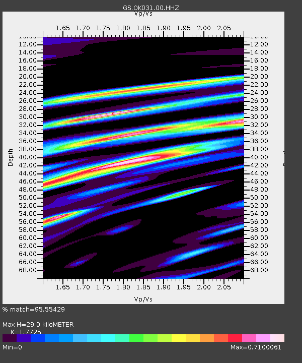
| Estimated Moho Depth: |
29.0 km |
| Estimated Crust Vp/Vs: |
1.77 |
| Assumed Crust Vp: |
6.426 km/s |
| Estimated Crust Vs: |
3.625 km/s |
| Estimated Crust Poisson's Ratio: |
0.27 |
|
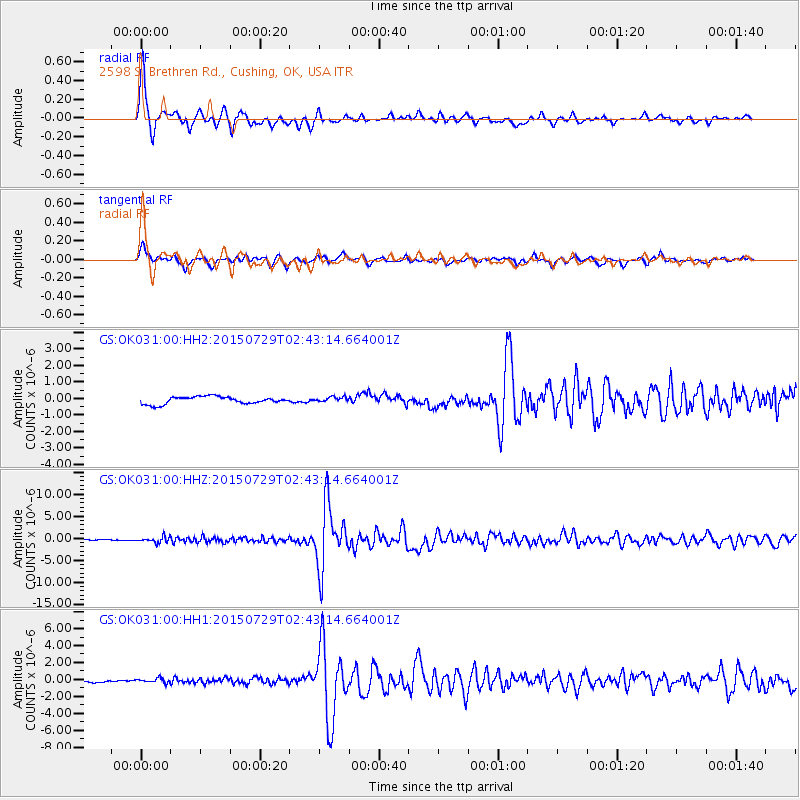
| Radial Match: |
95.55429 % |
| Radial Bump: |
400 |
| Transverse Match: |
84.17031 % |
| Transverse Bump: |
400 |
| SOD ConfigId: |
1085051 |
| Insert Time: |
2015-08-12 02:58:12.636 +0000 |
| GWidth: |
2.5 |
| Max Bumps: |
400 |
| Tol: |
0.001 |
|
Signal To Noise
| Channel | StoN | STA | LTA |
| GS:OK031:00:HHZ:20150729T02:43:14.664001Z | 11.213067 | 6.217628E-7 | 5.5449842E-8 |
| GS:OK031:00:HH1:20150729T02:43:14.664001Z | 1.1259888 | 2.3980894E-7 | 2.129763E-7 |
| GS:OK031:00:HH2:20150729T02:43:14.664001Z | 0.67748874 | 1.4782242E-7 | 2.181917E-7 |
| Arrivals |
| Ps | 3.7 SECOND |
| PpPs | 12 SECOND |
| PsPs/PpSs | 15 SECOND |


