You are here: Home > Network List > GS - US Geological Survey Networks Stations List
> Station DEC12 Decatur Surface Seismic Site, Decatur, IL, USA > Earthquake Result Viewer
DEC12 Decatur Surface Seismic Site, Decatur, IL, USA - Earthquake Result Viewer
| Earthquake location: |
Southern Alaska |
| Earthquake latitude/longitude: |
59.9/-153.1 |
| Earthquake time(UTC): |
2015/07/29 (210) 02:35:58 GMT |
| Earthquake Depth: |
118 km |
| Earthquake Magnitude: |
6.3 ML, 6.2 MWP, 6.2 MI, 6.3 MWW |
| Earthquake Catalog/Contributor: |
NEIC PDE/NEIC COMCAT |
|
| Network: |
GS US Geological Survey Networks |
| Station: |
DEC12 Decatur Surface Seismic Site, Decatur, IL, USA |
| Lat/Lon: |
39.91 N/88.91 W |
| Elevation: |
208 m |
|
| Distance: |
43.9 deg |
| Az: |
87.303 deg |
| Baz: |
319.111 deg |
| Ray Param: |
0.07185752 |
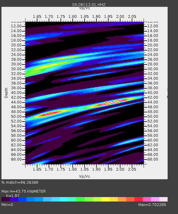
| Estimated Moho Depth: |
43.75 km |
| Estimated Crust Vp/Vs: |
1.97 |
| Assumed Crust Vp: |
6.444 km/s |
| Estimated Crust Vs: |
3.271 km/s |
| Estimated Crust Poisson's Ratio: |
0.33 |
|
| Radial Match: |
96.26369 % |
| Radial Bump: |
396 |
| Transverse Match: |
82.260086 % |
| Transverse Bump: |
400 |
| SOD ConfigId: |
1085051 |
| Insert Time: |
2015-08-12 02:58:37.760 +0000 |
| GWidth: |
2.5 |
| Max Bumps: |
400 |
| Tol: |
0.001 |
|
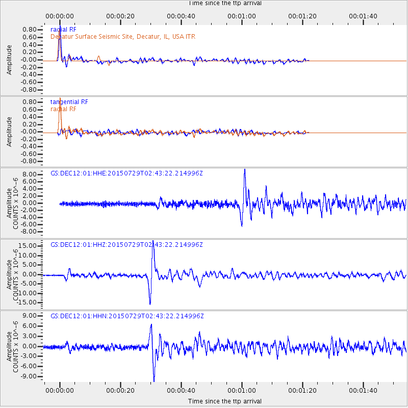
Signal To Noise
| Channel | StoN | STA | LTA |
| GS:DEC12:01:HHZ:20150729T02:43:22.214996Z | 9.482749 | 1.4088286E-6 | 1.4856752E-7 |
| GS:DEC12:01:HHN:20150729T02:43:22.214996Z | 2.751259 | 7.37941E-7 | 2.6821937E-7 |
| GS:DEC12:01:HHE:20150729T02:43:22.214996Z | 2.1038318 | 7.032388E-7 | 3.342657E-7 |
| Arrivals |
| Ps | 7.0 SECOND |
| PpPs | 19 SECOND |
| PsPs/PpSs | 26 SECOND |


