You are here: Home > Network List > AK - Alaska Regional Network Stations List
> Station FALS False Pass > Earthquake Result Viewer
FALS False Pass - Earthquake Result Viewer
| Earthquake location: |
Kyushu, Japan |
| Earthquake latitude/longitude: |
32.8/130.7 |
| Earthquake time(UTC): |
2016/04/15 (106) 16:25:06 GMT |
| Earthquake Depth: |
10 km |
| Earthquake Magnitude: |
7.0 MO |
| Earthquake Catalog/Contributor: |
NEIC PDE/NEIC ALERT |
|
| Network: |
AK Alaska Regional Network |
| Station: |
FALS False Pass |
| Lat/Lon: |
54.86 N/163.42 W |
| Elevation: |
46 m |
|
| Distance: |
50.3 deg |
| Az: |
43.302 deg |
| Baz: |
272.27 deg |
| Ray Param: |
0.068155095 |
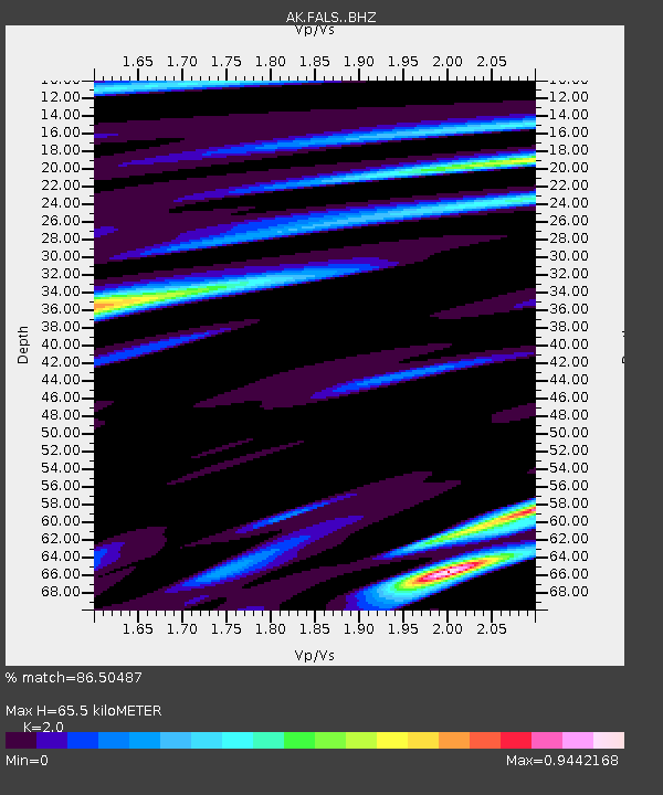
| Estimated Moho Depth: |
65.5 km |
| Estimated Crust Vp/Vs: |
2.00 |
| Assumed Crust Vp: |
5.989 km/s |
| Estimated Crust Vs: |
2.995 km/s |
| Estimated Crust Poisson's Ratio: |
0.33 |
|
| Radial Match: |
86.50487 % |
| Radial Bump: |
400 |
| Transverse Match: |
70.93716 % |
| Transverse Bump: |
400 |
| SOD ConfigId: |
7422571 |
| Insert Time: |
2019-04-22 07:07:26.804 +0000 |
| GWidth: |
2.5 |
| Max Bumps: |
400 |
| Tol: |
0.001 |
|

Signal To Noise
| Channel | StoN | STA | LTA |
| AK:FALS: :BHZ:20160415T16:33:31.64801Z | 4.1880856 | 3.504346E-6 | 8.367417E-7 |
| AK:FALS: :BHN:20160415T16:33:31.64801Z | 1.3912983 | 6.6258843E-7 | 4.7623752E-7 |
| AK:FALS: :BHE:20160415T16:33:31.64801Z | 1.1674458 | 1.3485864E-6 | 1.1551598E-6 |
| Arrivals |
| Ps | 11 SECOND |
| PpPs | 31 SECOND |
| PsPs/PpSs | 43 SECOND |


