You are here: Home > Network List > US - United States National Seismic Network Stations List
> Station DGMT Dagmar, Montana, USA > Earthquake Result Viewer
DGMT Dagmar, Montana, USA - Earthquake Result Viewer
*The percent match for this event was below the threshold and hence no stack was calculated.
| Earthquake location: |
Near Coast Of Central Chile |
| Earthquake latitude/longitude: |
-32.5/-71.7 |
| Earthquake time(UTC): |
2008/12/18 (353) 21:19:28 GMT |
| Earthquake Depth: |
18 km |
| Earthquake Magnitude: |
5.8 MB, 6.0 MS, 6.2 MW, 6.1 MW |
| Earthquake Catalog/Contributor: |
WHDF/NEIC |
|
| Network: |
US United States National Seismic Network |
| Station: |
DGMT Dagmar, Montana, USA |
| Lat/Lon: |
48.47 N/104.20 W |
| Elevation: |
0.0 m |
|
| Distance: |
85.6 deg |
| Az: |
339.004 deg |
| Baz: |
152.924 deg |
| Ray Param: |
$rayparam |
*The percent match for this event was below the threshold and hence was not used in the summary stack. |
|
| Radial Match: |
49.56849 % |
| Radial Bump: |
331 |
| Transverse Match: |
49.923893 % |
| Transverse Bump: |
306 |
| SOD ConfigId: |
2658 |
| Insert Time: |
2010-03-05 01:31:06.267 +0000 |
| GWidth: |
2.5 |
| Max Bumps: |
400 |
| Tol: |
0.001 |
|
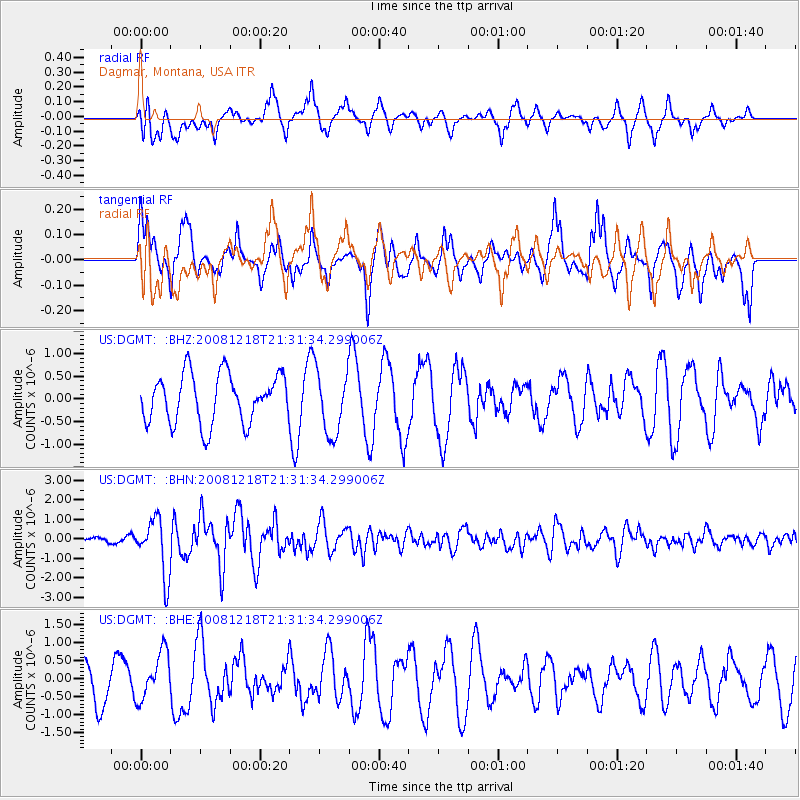
Signal To Noise
| Channel | StoN | STA | LTA |
| US:DGMT: :BHN:20081218T21:31:34.299006Z | 6.6026635 | 1.4593521E-6 | 2.2102476E-7 |
| US:DGMT: :BHE:20081218T21:31:34.299006Z | 1.3241665 | 6.5495607E-7 | 4.946176E-7 |
| US:DGMT: :BHZ:20081218T21:31:34.299006Z | 1.3115851 | 7.057912E-7 | 5.381208E-7 |
| Arrivals |
| Ps | |
| PpPs | |
| PsPs/PpSs | |


