You are here: Home > Network List > AK - Alaska Regional Network Stations List
> Station JIS Juneau Island, AK, USA > Earthquake Result Viewer
JIS Juneau Island, AK, USA - Earthquake Result Viewer
| Earthquake location: |
Kyushu, Japan |
| Earthquake latitude/longitude: |
32.8/130.7 |
| Earthquake time(UTC): |
2016/04/15 (106) 16:25:06 GMT |
| Earthquake Depth: |
10 km |
| Earthquake Magnitude: |
7.0 MO |
| Earthquake Catalog/Contributor: |
NEIC PDE/NEIC ALERT |
|
| Network: |
AK Alaska Regional Network |
| Station: |
JIS Juneau Island, AK, USA |
| Lat/Lon: |
58.28 N/134.38 W |
| Elevation: |
10 m |
|
| Distance: |
65.2 deg |
| Az: |
35.449 deg |
| Baz: |
292.386 deg |
| Ray Param: |
0.05843255 |
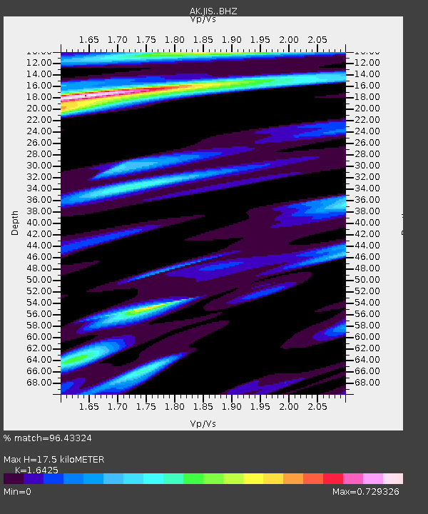
| Estimated Moho Depth: |
17.5 km |
| Estimated Crust Vp/Vs: |
1.64 |
| Assumed Crust Vp: |
6.566 km/s |
| Estimated Crust Vs: |
3.998 km/s |
| Estimated Crust Poisson's Ratio: |
0.21 |
|
| Radial Match: |
96.43324 % |
| Radial Bump: |
372 |
| Transverse Match: |
73.04422 % |
| Transverse Bump: |
400 |
| SOD ConfigId: |
7422571 |
| Insert Time: |
2019-04-22 07:07:36.867 +0000 |
| GWidth: |
2.5 |
| Max Bumps: |
400 |
| Tol: |
0.001 |
|

Signal To Noise
| Channel | StoN | STA | LTA |
| AK:JIS: :BHZ:20160415T16:35:16.228027Z | 5.06277 | 7.4910974E-7 | 1.479644E-7 |
| AK:JIS: :BHN:20160415T16:35:16.228027Z | 2.2034957 | 3.1675407E-7 | 1.4375071E-7 |
| AK:JIS: :BHE:20160415T16:35:16.228027Z | 2.0272648 | 4.761026E-7 | 2.3484972E-7 |
| Arrivals |
| Ps | 1.8 SECOND |
| PpPs | 6.7 SECOND |
| PsPs/PpSs | 8.5 SECOND |


