You are here: Home > Network List > US - United States National Seismic Network Stations List
> Station DGMT Dagmar, Montana, USA > Earthquake Result Viewer
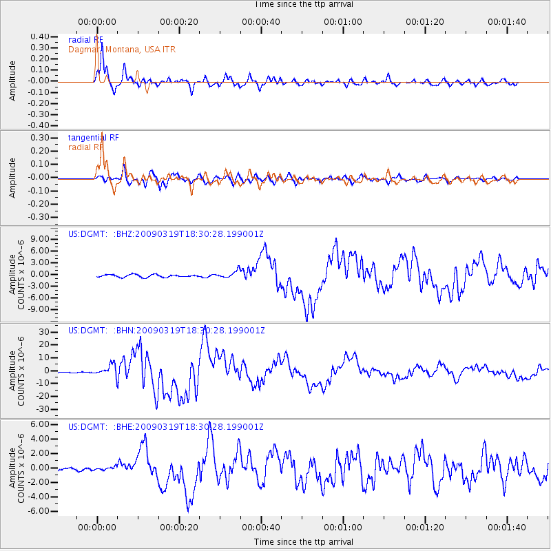
DGMT Dagmar, Montana, USA - Earthquake Result Viewer
*The percent match for this event was below the threshold and hence no stack was calculated.
| Earthquake location: |
Tonga Islands Region |
| Earthquake latitude/longitude: |
-23.0/-174.7 |
| Earthquake time(UTC): |
2009/03/19 (078) 18:17:40 GMT |
| Earthquake Depth: |
34 km |
| Earthquake Magnitude: |
7.0 MB, 7.6 MS, 7.6 MW, 7.6 MW |
| Earthquake Catalog/Contributor: |
WHDF/NEIC |
|
| Network: |
US United States National Seismic Network |
| Station: |
DGMT Dagmar, Montana, USA |
| Lat/Lon: |
48.47 N/104.20 W |
| Elevation: |
0.0 m |
|
| Distance: |
94.9 deg |
| Az: |
39.013 deg |
| Baz: |
240.61 deg |
| Ray Param: |
$rayparam |
*The percent match for this event was below the threshold and hence was not used in the summary stack. |
|
| Radial Match: |
98.14441 % |
| Radial Bump: |
400 |
| Transverse Match: |
91.706245 % |
| Transverse Bump: |
400 |
| SOD ConfigId: |
2658 |
| Insert Time: |
2010-03-05 01:31:12.903 +0000 |
| GWidth: |
2.5 |
| Max Bumps: |
400 |
| Tol: |
0.001 |
|
Signal To Noise
| Channel | StoN | STA | LTA |
| US:DGMT: :BHN:20090319T18:30:28.199001Z | 16.036177 | 4.4031367E-6 | 2.7457523E-7 |
| US:DGMT: :BHE:20090319T18:30:28.199001Z | 1.1745652 | 2.1919298E-7 | 1.8661628E-7 |
| US:DGMT: :BHZ:20090319T18:30:28.199001Z | 2.9207878 | 9.459382E-7 | 3.2386407E-7 |
| Arrivals |
| Ps | |
| PpPs | |
| PsPs/PpSs | |


