You are here: Home > Network List > AK - Alaska Regional Network Stations List
> Station SSP Sunshine Point, AK, USA > Earthquake Result Viewer
SSP Sunshine Point, AK, USA - Earthquake Result Viewer
| Earthquake location: |
Kyushu, Japan |
| Earthquake latitude/longitude: |
32.8/130.7 |
| Earthquake time(UTC): |
2016/04/15 (106) 16:25:06 GMT |
| Earthquake Depth: |
10 km |
| Earthquake Magnitude: |
7.0 MO |
| Earthquake Catalog/Contributor: |
NEIC PDE/NEIC ALERT |
|
| Network: |
AK Alaska Regional Network |
| Station: |
SSP Sunshine Point, AK, USA |
| Lat/Lon: |
60.18 N/142.84 W |
| Elevation: |
474 m |
|
| Distance: |
60.5 deg |
| Az: |
34.983 deg |
| Baz: |
284.916 deg |
| Ray Param: |
0.061512973 |
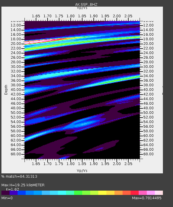
| Estimated Moho Depth: |
19.25 km |
| Estimated Crust Vp/Vs: |
1.62 |
| Assumed Crust Vp: |
6.566 km/s |
| Estimated Crust Vs: |
4.053 km/s |
| Estimated Crust Poisson's Ratio: |
0.19 |
|
| Radial Match: |
84.31313 % |
| Radial Bump: |
400 |
| Transverse Match: |
75.78409 % |
| Transverse Bump: |
400 |
| SOD ConfigId: |
7422571 |
| Insert Time: |
2019-04-22 07:08:05.162 +0000 |
| GWidth: |
2.5 |
| Max Bumps: |
400 |
| Tol: |
0.001 |
|

Signal To Noise
| Channel | StoN | STA | LTA |
| AK:SSP: :BHZ:20160415T16:34:44.828003Z | 2.6896853 | 1.6466911E-6 | 6.122244E-7 |
| AK:SSP: :BHN:20160415T16:34:44.828003Z | 1.1181606 | 1.3141704E-6 | 1.1752966E-6 |
| AK:SSP: :BHE:20160415T16:34:44.828003Z | 2.0872972 | 1.5335505E-6 | 7.3470636E-7 |
| Arrivals |
| Ps | 1.9 SECOND |
| PpPs | 7.3 SECOND |
| PsPs/PpSs | 9.2 SECOND |


