You are here: Home > Network List > AK - Alaska Regional Network Stations List
> Station SUCK Suckling Hills, AK, USA > Earthquake Result Viewer
SUCK Suckling Hills, AK, USA - Earthquake Result Viewer
| Earthquake location: |
Kyushu, Japan |
| Earthquake latitude/longitude: |
32.8/130.7 |
| Earthquake time(UTC): |
2016/04/15 (106) 16:25:06 GMT |
| Earthquake Depth: |
10 km |
| Earthquake Magnitude: |
7.0 MO |
| Earthquake Catalog/Contributor: |
NEIC PDE/NEIC ALERT |
|
| Network: |
AK Alaska Regional Network |
| Station: |
SUCK Suckling Hills, AK, USA |
| Lat/Lon: |
60.07 N/143.78 W |
| Elevation: |
467 m |
|
| Distance: |
60.0 deg |
| Az: |
35.239 deg |
| Baz: |
284.23 deg |
| Ray Param: |
0.06179467 |
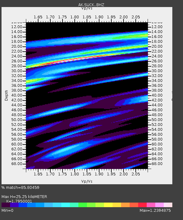
| Estimated Moho Depth: |
25.25 km |
| Estimated Crust Vp/Vs: |
1.80 |
| Assumed Crust Vp: |
6.566 km/s |
| Estimated Crust Vs: |
3.658 km/s |
| Estimated Crust Poisson's Ratio: |
0.27 |
|
| Radial Match: |
85.80459 % |
| Radial Bump: |
400 |
| Transverse Match: |
78.763466 % |
| Transverse Bump: |
400 |
| SOD ConfigId: |
7422571 |
| Insert Time: |
2019-04-22 07:08:06.874 +0000 |
| GWidth: |
2.5 |
| Max Bumps: |
400 |
| Tol: |
0.001 |
|

Signal To Noise
| Channel | StoN | STA | LTA |
| AK:SUCK: :BHZ:20160415T16:34:41.888Z | 1.7679756 | 1.7791223E-6 | 1.0063047E-6 |
| AK:SUCK: :BHN:20160415T16:34:41.888Z | 1.586464 | 1.6472669E-6 | 1.038326E-6 |
| AK:SUCK: :BHE:20160415T16:34:41.888Z | 2.451446 | 1.6832545E-6 | 6.8663735E-7 |
| Arrivals |
| Ps | 3.2 SECOND |
| PpPs | 10 SECOND |
| PsPs/PpSs | 13 SECOND |


