You are here: Home > Network List > AT - Alaska Tsunami Warning Seismic System Stations List
> Station OHAK Old Harbor, Alaska > Earthquake Result Viewer
OHAK Old Harbor, Alaska - Earthquake Result Viewer
| Earthquake location: |
Kyushu, Japan |
| Earthquake latitude/longitude: |
32.8/130.7 |
| Earthquake time(UTC): |
2016/04/15 (106) 16:25:06 GMT |
| Earthquake Depth: |
10 km |
| Earthquake Magnitude: |
7.0 MO |
| Earthquake Catalog/Contributor: |
NEIC PDE/NEIC ALERT |
|
| Network: |
AT Alaska Tsunami Warning Seismic System |
| Station: |
OHAK Old Harbor, Alaska |
| Lat/Lon: |
57.22 N/153.29 W |
| Elevation: |
78 m |
|
| Distance: |
55.7 deg |
| Az: |
39.692 deg |
| Baz: |
278.487 deg |
| Ray Param: |
0.06460491 |
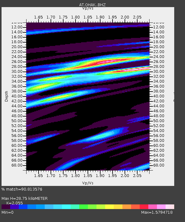
| Estimated Moho Depth: |
28.75 km |
| Estimated Crust Vp/Vs: |
2.06 |
| Assumed Crust Vp: |
6.134 km/s |
| Estimated Crust Vs: |
2.985 km/s |
| Estimated Crust Poisson's Ratio: |
0.34 |
|
| Radial Match: |
90.813576 % |
| Radial Bump: |
335 |
| Transverse Match: |
76.07625 % |
| Transverse Bump: |
400 |
| SOD ConfigId: |
7422571 |
| Insert Time: |
2019-04-22 07:08:18.319 +0000 |
| GWidth: |
2.5 |
| Max Bumps: |
400 |
| Tol: |
0.001 |
|

Signal To Noise
| Channel | StoN | STA | LTA |
| AT:OHAK: :BHZ:20160415T16:34:11.679993Z | 3.3017492 | 3.0616623E-6 | 9.2728493E-7 |
| AT:OHAK: :BHN:20160415T16:34:11.679993Z | 1.3032784 | 8.9152394E-7 | 6.840625E-7 |
| AT:OHAK: :BHE:20160415T16:34:11.679993Z | 1.9874548 | 1.6298693E-6 | 8.200787E-7 |
| Arrivals |
| Ps | 5.1 SECOND |
| PpPs | 14 SECOND |
| PsPs/PpSs | 19 SECOND |


