You are here: Home > Network List > US - United States National Seismic Network Stations List
> Station DGMT Dagmar, Montana, USA > Earthquake Result Viewer
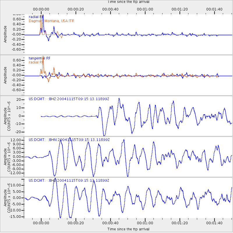
DGMT Dagmar, Montana, USA - Earthquake Result Viewer
*The percent match for this event was below the threshold and hence no stack was calculated.
| Earthquake location: |
Near West Coast Of Colombia |
| Earthquake latitude/longitude: |
4.7/-77.5 |
| Earthquake time(UTC): |
2004/11/15 (320) 09:06:56 GMT |
| Earthquake Depth: |
15 km |
| Earthquake Magnitude: |
6.6 MB, 7.1 MS, 7.2 MW, 7.1 MW |
| Earthquake Catalog/Contributor: |
WHDF/NEIC |
|
| Network: |
US United States National Seismic Network |
| Station: |
DGMT Dagmar, Montana, USA |
| Lat/Lon: |
48.47 N/104.20 W |
| Elevation: |
0.0 m |
|
| Distance: |
49.2 deg |
| Az: |
336.747 deg |
| Baz: |
143.753 deg |
| Ray Param: |
$rayparam |
*The percent match for this event was below the threshold and hence was not used in the summary stack. |
|
| Radial Match: |
95.05758 % |
| Radial Bump: |
266 |
| Transverse Match: |
70.66072 % |
| Transverse Bump: |
400 |
| SOD ConfigId: |
110177 |
| Insert Time: |
2010-03-05 01:31:24.149 +0000 |
| GWidth: |
2.5 |
| Max Bumps: |
400 |
| Tol: |
0.001 |
|
Signal To Noise
| Channel | StoN | STA | LTA |
| US:DGMT: :BHN:20041115T09:15:13.11899Z | 1.4179695 | 1.2653724E-6 | 8.9238335E-7 |
| US:DGMT: :BHE:20041115T09:15:13.11899Z | 1.4969262 | 2.060732E-6 | 1.3766423E-6 |
| US:DGMT: :BHZ:20041115T09:15:13.11899Z | 10.714114 | 4.9571768E-6 | 4.6267724E-7 |
| Arrivals |
| Ps | |
| PpPs | |
| PsPs/PpSs | |


