You are here: Home > Network List > US - United States National Seismic Network Stations List
> Station BLA Blacksburg, Virginia, USA > Earthquake Result Viewer
BLA Blacksburg, Virginia, USA - Earthquake Result Viewer
| Earthquake location: |
Windward Islands |
| Earthquake latitude/longitude: |
11.1/-62.6 |
| Earthquake time(UTC): |
2000/10/04 (278) 14:37:44 GMT |
| Earthquake Depth: |
110 km |
| Earthquake Magnitude: |
5.6 MB, 5.4 MS, 6.1 MW, 5.9 MD |
| Earthquake Catalog/Contributor: |
WHDF/NEIC |
|
| Network: |
US United States National Seismic Network |
| Station: |
BLA Blacksburg, Virginia, USA |
| Lat/Lon: |
37.21 N/80.42 W |
| Elevation: |
634 m |
|
| Distance: |
30.5 deg |
| Az: |
331.196 deg |
| Baz: |
143.678 deg |
| Ray Param: |
0.07911844 |
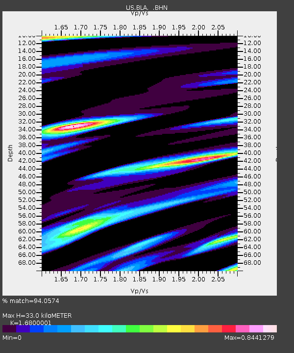
| Estimated Moho Depth: |
33.0 km |
| Estimated Crust Vp/Vs: |
1.68 |
| Assumed Crust Vp: |
6.159 km/s |
| Estimated Crust Vs: |
3.666 km/s |
| Estimated Crust Poisson's Ratio: |
0.23 |
|
| Radial Match: |
94.0574 % |
| Radial Bump: |
331 |
| Transverse Match: |
73.91439 % |
| Transverse Bump: |
400 |
| SOD ConfigId: |
110165 |
| Insert Time: |
2010-03-05 01:31:29.332 +0000 |
| GWidth: |
2.5 |
| Max Bumps: |
400 |
| Tol: |
0.001 |
|
Signal To Noise
| Channel | StoN | STA | LTA |
| US:BLA: :BHN:20001004T14:43:16.978003Z | 1.5555466 | 3.8326496E-7 | 2.4638604E-7 |
| US:BLA: :BHE:20001004T14:43:16.97901Z | 1.441376 | 2.2309719E-7 | 1.547807E-7 |
| US:BLA: :BHZ:20001004T14:43:16.97901Z | 3.4051626 | 7.797632E-7 | 2.2899441E-7 |
| Arrivals |
| Ps | 3.9 SECOND |
| PpPs | 13 SECOND |
| PsPs/PpSs | 17 SECOND |


