You are here: Home > Network List > CN - Canadian National Seismograph Network Stations List
> Station WHY Whitehorse, YT, CA > Earthquake Result Viewer
WHY Whitehorse, YT, CA - Earthquake Result Viewer

| Earthquake location: |
Kyushu, Japan |
| Earthquake latitude/longitude: |
32.8/130.7 |
| Earthquake time(UTC): |
2016/04/15 (106) 16:25:06 GMT |
| Earthquake Depth: |
10 km |
| Earthquake Magnitude: |
7.0 MO |
| Earthquake Catalog/Contributor: |
NEIC PDE/NEIC ALERT |
|
| Network: |
CN Canadian National Seismograph Network |
| Station: |
WHY Whitehorse, YT, CA |
| Lat/Lon: |
60.66 N/134.88 W |
| Elevation: |
1273 m |
|
| Distance: |
64.1 deg |
| Az: |
33.093 deg |
| Baz: |
290.948 deg |
| Ray Param: |
0.05915965 |
| Estimated Moho Depth: |
38.5 km |
| Estimated Crust Vp/Vs: |
1.68 |
| Assumed Crust Vp: |
6.419 km/s |
| Estimated Crust Vs: |
3.832 km/s |
| Estimated Crust Poisson's Ratio: |
0.22 |
|
| Radial Match: |
95.85775 % |
| Radial Bump: |
314 |
| Transverse Match: |
85.34358 % |
| Transverse Bump: |
400 |
| SOD ConfigId: |
7422571 |
| Insert Time: |
2019-04-22 07:10:42.757 +0000 |
| GWidth: |
2.5 |
| Max Bumps: |
400 |
| Tol: |
0.001 |
|
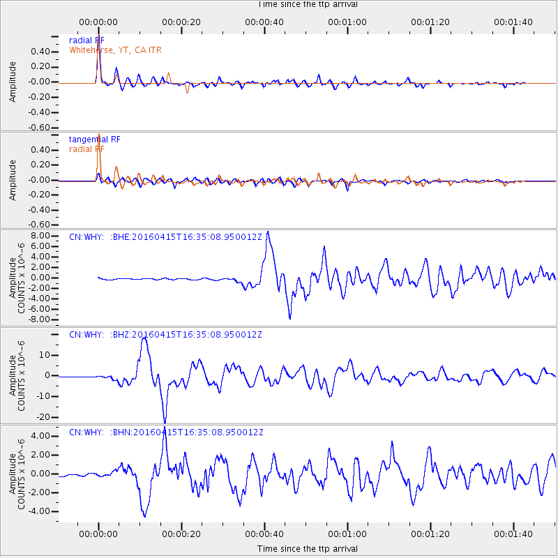
Signal To Noise
| Channel | StoN | STA | LTA |
| CN:WHY: :BHZ:20160415T16:35:08.950012Z | 4.299239 | 9.811997E-7 | 2.2822637E-7 |
| CN:WHY: :BHN:20160415T16:35:08.950012Z | 1.6745937 | 2.8969114E-7 | 1.729919E-7 |
| CN:WHY: :BHE:20160415T16:35:08.950012Z | 3.2398882 | 3.5421624E-7 | 1.09329775E-7 |
| Arrivals |
| Ps | 4.2 SECOND |
| PpPs | 15 SECOND |
| PsPs/PpSs | 20 SECOND |


