You are here: Home > Network List > US - United States National Seismic Network Stations List
> Station BLA Blacksburg, Virginia, USA > Earthquake Result Viewer
BLA Blacksburg, Virginia, USA - Earthquake Result Viewer
| Earthquake location: |
Near East Coast Of Kamchatka |
| Earthquake latitude/longitude: |
56.3/163.8 |
| Earthquake time(UTC): |
2001/08/02 (214) 23:41:06 GMT |
| Earthquake Depth: |
14 km |
| Earthquake Magnitude: |
5.9 MB, 6.2 MS, 6.3 MW, 6.2 ME |
| Earthquake Catalog/Contributor: |
WHDF/NEIC |
|
| Network: |
US United States National Seismic Network |
| Station: |
BLA Blacksburg, Virginia, USA |
| Lat/Lon: |
37.21 N/80.42 W |
| Elevation: |
634 m |
|
| Distance: |
72.2 deg |
| Az: |
49.029 deg |
| Baz: |
328.148 deg |
| Ray Param: |
0.053819105 |
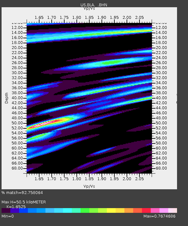
| Estimated Moho Depth: |
50.5 km |
| Estimated Crust Vp/Vs: |
1.65 |
| Assumed Crust Vp: |
6.159 km/s |
| Estimated Crust Vs: |
3.727 km/s |
| Estimated Crust Poisson's Ratio: |
0.21 |
|
| Radial Match: |
92.758064 % |
| Radial Bump: |
306 |
| Transverse Match: |
79.62757 % |
| Transverse Bump: |
400 |
| SOD ConfigId: |
110165 |
| Insert Time: |
2010-03-05 01:31:44.723 +0000 |
| GWidth: |
2.5 |
| Max Bumps: |
400 |
| Tol: |
0.001 |
|

Signal To Noise
| Channel | StoN | STA | LTA |
| US:BLA: :BHN:20010802T23:51:59.18001Z | 1.4867752 | 1.6460486E-7 | 1.10712676E-7 |
| US:BLA: :BHE:20010802T23:51:59.18001Z | 0.672038 | 7.259785E-8 | 1.08026406E-7 |
| US:BLA: :BHZ:20010802T23:51:59.18001Z | 2.6010518 | 3.0416572E-7 | 1.1693951E-7 |
| Arrivals |
| Ps | 5.5 SECOND |
| PpPs | 21 SECOND |
| PsPs/PpSs | 27 SECOND |


