You are here: Home > Network List > IU - Global Seismograph Network (GSN - IRIS/USGS) Stations List
> Station PAYG Puerto Ayora, Galapagos Islands > Earthquake Result Viewer
PAYG Puerto Ayora, Galapagos Islands - Earthquake Result Viewer
| Earthquake location: |
Southern Alaska |
| Earthquake latitude/longitude: |
59.9/-153.1 |
| Earthquake time(UTC): |
2015/07/29 (210) 02:35:58 GMT |
| Earthquake Depth: |
118 km |
| Earthquake Magnitude: |
6.3 ML, 6.2 MWP, 6.2 MI, 6.3 MWW |
| Earthquake Catalog/Contributor: |
NEIC PDE/NEIC COMCAT |
|
| Network: |
IU Global Seismograph Network (GSN - IRIS/USGS) |
| Station: |
PAYG Puerto Ayora, Galapagos Islands |
| Lat/Lon: |
0.67 S/90.29 W |
| Elevation: |
270 m |
|
| Distance: |
77.3 deg |
| Az: |
114.264 deg |
| Baz: |
332.64 deg |
| Ray Param: |
0.050158434 |
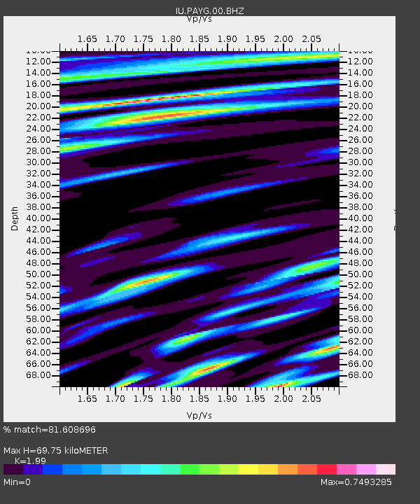
| Estimated Moho Depth: |
69.75 km |
| Estimated Crust Vp/Vs: |
1.99 |
| Assumed Crust Vp: |
4.802 km/s |
| Estimated Crust Vs: |
2.413 km/s |
| Estimated Crust Poisson's Ratio: |
0.33 |
|
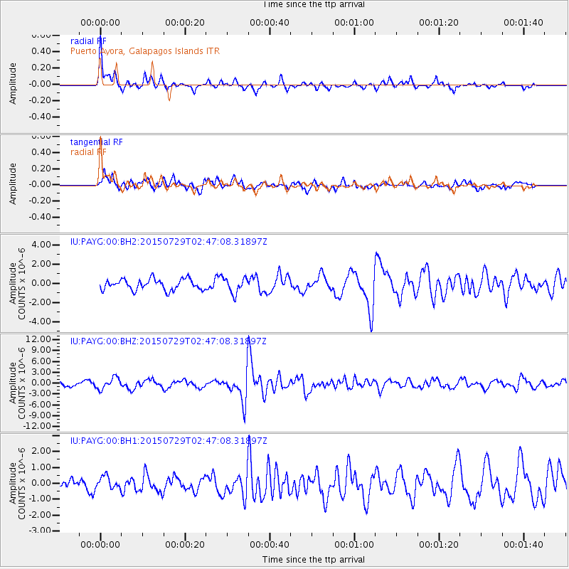
| Radial Match: |
81.608696 % |
| Radial Bump: |
385 |
| Transverse Match: |
79.62024 % |
| Transverse Bump: |
400 |
| SOD ConfigId: |
1085051 |
| Insert Time: |
2015-08-12 03:01:35.088 +0000 |
| GWidth: |
2.5 |
| Max Bumps: |
400 |
| Tol: |
0.001 |
|
Signal To Noise
| Channel | StoN | STA | LTA |
| IU:PAYG:00:BHZ:20150729T02:47:08.31897Z | 2.6779304 | 1.5965124E-6 | 5.96174E-7 |
| IU:PAYG:00:BH1:20150729T02:47:08.31897Z | 0.61899173 | 3.905818E-7 | 6.3099674E-7 |
| IU:PAYG:00:BH2:20150729T02:47:08.31897Z | 1.4250141 | 8.008127E-7 | 5.6196825E-7 |
| Arrivals |
| Ps | 15 SECOND |
| PpPs | 43 SECOND |
| PsPs/PpSs | 57 SECOND |


