You are here: Home > Network List > NN - Western Great Basin/Eastern Sierra Nevada Stations List
> Station EMB Emerald Bay, California w84 > Earthquake Result Viewer
EMB Emerald Bay, California w84 - Earthquake Result Viewer
| Earthquake location: |
Kyushu, Japan |
| Earthquake latitude/longitude: |
32.8/130.7 |
| Earthquake time(UTC): |
2016/04/15 (106) 16:25:06 GMT |
| Earthquake Depth: |
10 km |
| Earthquake Magnitude: |
7.0 MO |
| Earthquake Catalog/Contributor: |
NEIC PDE/NEIC ALERT |
|
| Network: |
NN Western Great Basin/Eastern Sierra Nevada |
| Station: |
EMB Emerald Bay, California w84 |
| Lat/Lon: |
38.97 N/120.10 W |
| Elevation: |
2134 m |
|
| Distance: |
83.0 deg |
| Az: |
47.884 deg |
| Baz: |
306.712 deg |
| Ray Param: |
0.046499126 |
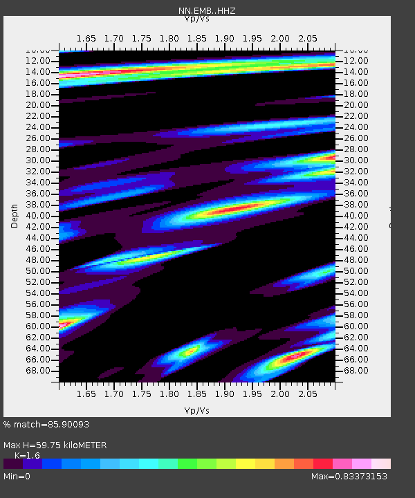
| Estimated Moho Depth: |
59.75 km |
| Estimated Crust Vp/Vs: |
1.60 |
| Assumed Crust Vp: |
6.597 km/s |
| Estimated Crust Vs: |
4.123 km/s |
| Estimated Crust Poisson's Ratio: |
0.18 |
|
| Radial Match: |
85.90093 % |
| Radial Bump: |
379 |
| Transverse Match: |
79.982834 % |
| Transverse Bump: |
400 |
| SOD ConfigId: |
7422571 |
| Insert Time: |
2019-04-22 07:13:10.196 +0000 |
| GWidth: |
2.5 |
| Max Bumps: |
400 |
| Tol: |
0.001 |
|

Signal To Noise
| Channel | StoN | STA | LTA |
| NN:EMB: :HHZ:20160415T16:36:59.91803Z | 2.557302 | 7.823065E-7 | 3.0591087E-7 |
| NN:EMB: :HHN:20160415T16:36:59.91803Z | 0.67752177 | 3.7842844E-7 | 5.58548E-7 |
| NN:EMB: :HHE:20160415T16:36:59.91803Z | 0.87190264 | 4.6575946E-7 | 5.3418745E-7 |
| Arrivals |
| Ps | 5.6 SECOND |
| PpPs | 23 SECOND |
| PsPs/PpSs | 28 SECOND |


