You are here: Home > Network List > US - United States National Seismic Network Stations List
> Station BLA Blacksburg, Virginia, USA > Earthquake Result Viewer
BLA Blacksburg, Virginia, USA - Earthquake Result Viewer
| Earthquake location: |
Near Coast Of Northern Chile |
| Earthquake latitude/longitude: |
-27.5/-70.6 |
| Earthquake time(UTC): |
2002/04/18 (108) 16:08:36 GMT |
| Earthquake Depth: |
62 km |
| Earthquake Magnitude: |
6.2 MB, 6.7 MW, 6.6 MW |
| Earthquake Catalog/Contributor: |
WHDF/NEIC |
|
| Network: |
US United States National Seismic Network |
| Station: |
BLA Blacksburg, Virginia, USA |
| Lat/Lon: |
37.21 N/80.42 W |
| Elevation: |
634 m |
|
| Distance: |
65.1 deg |
| Az: |
351.351 deg |
| Baz: |
170.371 deg |
| Ray Param: |
0.05837335 |
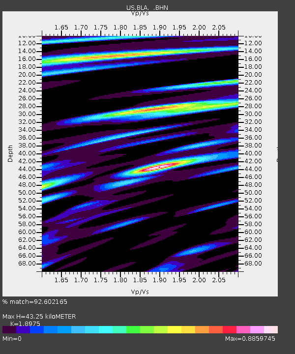
| Estimated Moho Depth: |
43.25 km |
| Estimated Crust Vp/Vs: |
1.90 |
| Assumed Crust Vp: |
6.159 km/s |
| Estimated Crust Vs: |
3.246 km/s |
| Estimated Crust Poisson's Ratio: |
0.31 |
|
| Radial Match: |
92.602165 % |
| Radial Bump: |
400 |
| Transverse Match: |
86.034485 % |
| Transverse Bump: |
400 |
| SOD ConfigId: |
110177 |
| Insert Time: |
2010-03-05 01:32:08.969 +0000 |
| GWidth: |
2.5 |
| Max Bumps: |
400 |
| Tol: |
0.001 |
|
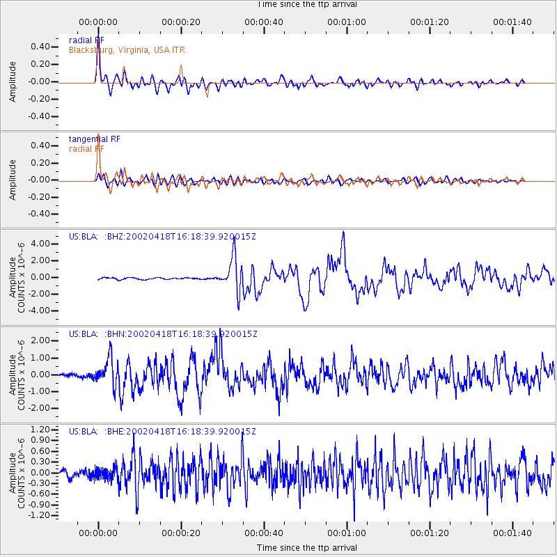
Signal To Noise
| Channel | StoN | STA | LTA |
| US:BLA: :BHN:20020418T16:18:39.920015Z | 4.7032623 | 8.2478954E-7 | 1.7536541E-7 |
| US:BLA: :BHE:20020418T16:18:39.920015Z | 1.8912985 | 1.6441935E-7 | 8.6934634E-8 |
| US:BLA: :BHZ:20020418T16:18:39.920015Z | 20.563566 | 2.0853433E-6 | 1.0140962E-7 |
| Arrivals |
| Ps | 6.5 SECOND |
| PpPs | 20 SECOND |
| PsPs/PpSs | 26 SECOND |


