You are here: Home > Network List > RV - Regional Alberta Seismic Observatory for Earthquake Studies Network Stations List
> Station LGPLA Lodgepole, Alberta > Earthquake Result Viewer
LGPLA Lodgepole, Alberta - Earthquake Result Viewer
| Earthquake location: |
Kyushu, Japan |
| Earthquake latitude/longitude: |
32.8/130.7 |
| Earthquake time(UTC): |
2016/04/15 (106) 16:25:06 GMT |
| Earthquake Depth: |
10 km |
| Earthquake Magnitude: |
7.0 MO |
| Earthquake Catalog/Contributor: |
NEIC PDE/NEIC ALERT |
|
| Network: |
RV Regional Alberta Seismic Observatory for Earthquake Studies Network |
| Station: |
LGPLA Lodgepole, Alberta |
| Lat/Lon: |
53.12 N/115.36 W |
| Elevation: |
877 m |
|
| Distance: |
77.0 deg |
| Az: |
34.429 deg |
| Baz: |
307.801 deg |
| Ray Param: |
0.05058385 |
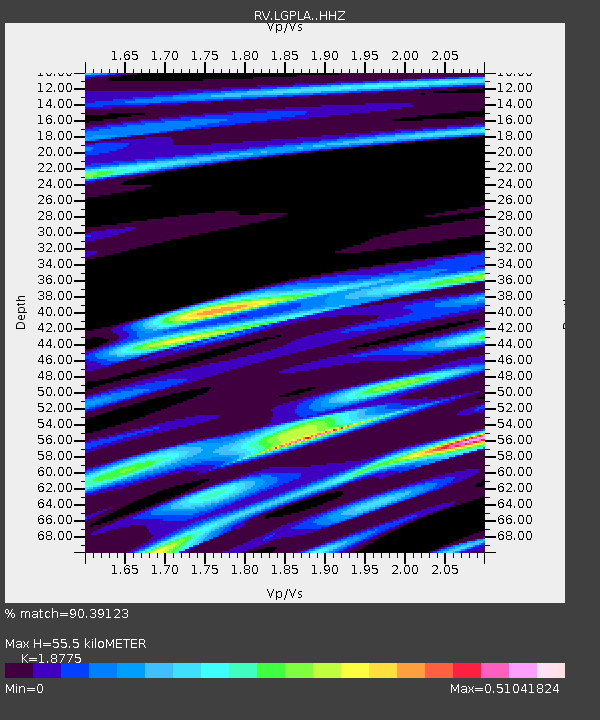
| Estimated Moho Depth: |
55.5 km |
| Estimated Crust Vp/Vs: |
1.88 |
| Assumed Crust Vp: |
6.426 km/s |
| Estimated Crust Vs: |
3.423 km/s |
| Estimated Crust Poisson's Ratio: |
0.30 |
|
| Radial Match: |
90.39123 % |
| Radial Bump: |
400 |
| Transverse Match: |
71.983284 % |
| Transverse Bump: |
400 |
| SOD ConfigId: |
7422571 |
| Insert Time: |
2019-04-22 07:14:21.985 +0000 |
| GWidth: |
2.5 |
| Max Bumps: |
400 |
| Tol: |
0.001 |
|

Signal To Noise
| Channel | StoN | STA | LTA |
| RV:LGPLA: :HHZ:20160415T16:36:27.900024Z | 8.386171 | 1.8188725E-6 | 2.168895E-7 |
| RV:LGPLA: :HHN:20160415T16:36:27.900024Z | 2.592405 | 1.030779E-6 | 3.9761494E-7 |
| RV:LGPLA: :HHE:20160415T16:36:27.900024Z | 1.5051668 | 4.112876E-7 | 2.7325052E-7 |
| Arrivals |
| Ps | 7.8 SECOND |
| PpPs | 24 SECOND |
| PsPs/PpSs | 32 SECOND |


