You are here: Home > Network List > RV - Regional Alberta Seismic Observatory for Earthquake Studies Network Stations List
> Station MANA Manning, AB > Earthquake Result Viewer
MANA Manning, AB - Earthquake Result Viewer
| Earthquake location: |
Kyushu, Japan |
| Earthquake latitude/longitude: |
32.8/130.7 |
| Earthquake time(UTC): |
2016/04/15 (106) 16:25:06 GMT |
| Earthquake Depth: |
10 km |
| Earthquake Magnitude: |
7.0 MO |
| Earthquake Catalog/Contributor: |
NEIC PDE/NEIC ALERT |
|
| Network: |
RV Regional Alberta Seismic Observatory for Earthquake Studies Network |
| Station: |
MANA Manning, AB |
| Lat/Lon: |
56.86 N/117.64 W |
| Elevation: |
480 m |
|
| Distance: |
73.8 deg |
| Az: |
32.13 deg |
| Baz: |
305.356 deg |
| Ray Param: |
0.052789107 |
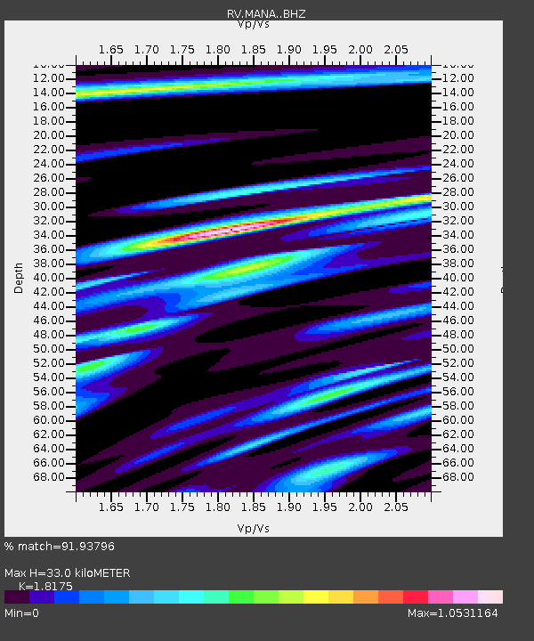
| Estimated Moho Depth: |
33.0 km |
| Estimated Crust Vp/Vs: |
1.82 |
| Assumed Crust Vp: |
6.444 km/s |
| Estimated Crust Vs: |
3.545 km/s |
| Estimated Crust Poisson's Ratio: |
0.28 |
|
| Radial Match: |
91.93796 % |
| Radial Bump: |
400 |
| Transverse Match: |
65.208374 % |
| Transverse Bump: |
400 |
| SOD ConfigId: |
7422571 |
| Insert Time: |
2019-04-22 07:14:22.302 +0000 |
| GWidth: |
2.5 |
| Max Bumps: |
400 |
| Tol: |
0.001 |
|

Signal To Noise
| Channel | StoN | STA | LTA |
| RV:MANA: :BHZ:20160415T16:36:09.049988Z | 10.855981 | 2.2934094E-6 | 2.1125767E-7 |
| RV:MANA: :BHN:20160415T16:36:09.049988Z | 1.771201 | 8.725018E-7 | 4.926046E-7 |
| RV:MANA: :BHE:20160415T16:36:09.049988Z | 1.290422 | 6.442141E-7 | 4.9922744E-7 |
| Arrivals |
| Ps | 4.3 SECOND |
| PpPs | 14 SECOND |
| PsPs/PpSs | 18 SECOND |


