You are here: Home > Network List > TA - USArray Transportable Network (new EarthScope stations) Stations List
> Station B05D Stanwood, WA, USA > Earthquake Result Viewer
B05D Stanwood, WA, USA - Earthquake Result Viewer
| Earthquake location: |
Kyushu, Japan |
| Earthquake latitude/longitude: |
32.8/130.7 |
| Earthquake time(UTC): |
2016/04/15 (106) 16:25:06 GMT |
| Earthquake Depth: |
10 km |
| Earthquake Magnitude: |
7.0 MO |
| Earthquake Catalog/Contributor: |
NEIC PDE/NEIC ALERT |
|
| Network: |
TA USArray Transportable Network (new EarthScope stations) |
| Station: |
B05D Stanwood, WA, USA |
| Lat/Lon: |
48.26 N/122.10 W |
| Elevation: |
153 m |
|
| Distance: |
76.4 deg |
| Az: |
41.05 deg |
| Baz: |
304.113 deg |
| Ray Param: |
0.05100145 |
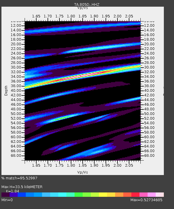
| Estimated Moho Depth: |
33.5 km |
| Estimated Crust Vp/Vs: |
1.84 |
| Assumed Crust Vp: |
6.566 km/s |
| Estimated Crust Vs: |
3.569 km/s |
| Estimated Crust Poisson's Ratio: |
0.29 |
|
| Radial Match: |
95.52997 % |
| Radial Bump: |
400 |
| Transverse Match: |
92.7038 % |
| Transverse Bump: |
400 |
| SOD ConfigId: |
7422571 |
| Insert Time: |
2019-04-22 07:15:02.617 +0000 |
| GWidth: |
2.5 |
| Max Bumps: |
400 |
| Tol: |
0.001 |
|

Signal To Noise
| Channel | StoN | STA | LTA |
| TA:B05D: :HHZ:20160415T16:36:24.390015Z | 3.2527807 | 1.1048319E-6 | 3.3965767E-7 |
| TA:B05D: :HHN:20160415T16:36:24.390015Z | 1.2559003 | 2.955242E-7 | 2.3530865E-7 |
| TA:B05D: :HHE:20160415T16:36:24.390015Z | 1.2805288 | 3.212939E-7 | 2.509072E-7 |
| Arrivals |
| Ps | 4.4 SECOND |
| PpPs | 14 SECOND |
| PsPs/PpSs | 18 SECOND |


