You are here: Home > Network List > US - United States National Seismic Network Stations List
> Station BLA Blacksburg, Virginia, USA > Earthquake Result Viewer
BLA Blacksburg, Virginia, USA - Earthquake Result Viewer
| Earthquake location: |
Kamchatka Peninsula, Russia |
| Earthquake latitude/longitude: |
55.5/160.0 |
| Earthquake time(UTC): |
2003/06/16 (167) 22:08:02 GMT |
| Earthquake Depth: |
175 km |
| Earthquake Magnitude: |
6.3 MB, 6.9 MW, 6.9 MW |
| Earthquake Catalog/Contributor: |
WHDF/NEIC |
|
| Network: |
US United States National Seismic Network |
| Station: |
BLA Blacksburg, Virginia, USA |
| Lat/Lon: |
37.21 N/80.42 W |
| Elevation: |
634 m |
|
| Distance: |
74.3 deg |
| Az: |
46.16 deg |
| Baz: |
329.059 deg |
| Ray Param: |
0.051979333 |
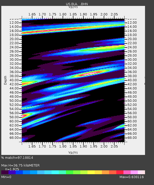
| Estimated Moho Depth: |
36.75 km |
| Estimated Crust Vp/Vs: |
1.92 |
| Assumed Crust Vp: |
6.159 km/s |
| Estimated Crust Vs: |
3.199 km/s |
| Estimated Crust Poisson's Ratio: |
0.32 |
|
| Radial Match: |
97.18814 % |
| Radial Bump: |
345 |
| Transverse Match: |
90.37253 % |
| Transverse Bump: |
400 |
| SOD ConfigId: |
110177 |
| Insert Time: |
2010-03-05 01:32:38.186 +0000 |
| GWidth: |
2.5 |
| Max Bumps: |
400 |
| Tol: |
0.001 |
|
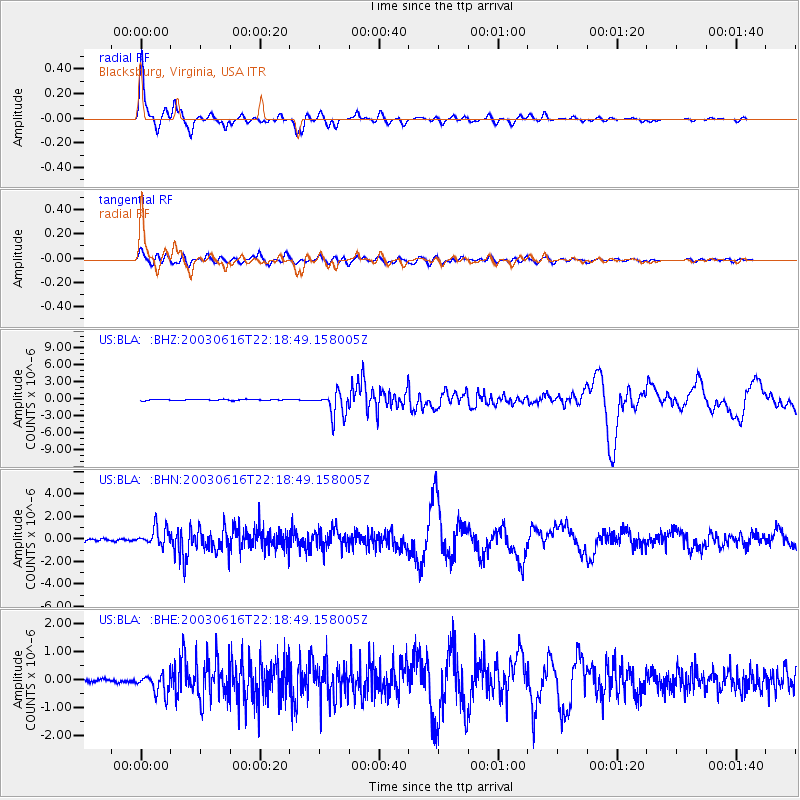
Signal To Noise
| Channel | StoN | STA | LTA |
| US:BLA: :BHN:20030616T22:18:49.158005Z | 6.7230606 | 7.979339E-7 | 1.1868611E-7 |
| US:BLA: :BHE:20030616T22:18:49.158005Z | 3.7255216 | 3.3797534E-7 | 9.071893E-8 |
| US:BLA: :BHZ:20030616T22:18:49.158005Z | 20.122574 | 2.1388448E-6 | 1.0629083E-7 |
| Arrivals |
| Ps | 5.7 SECOND |
| PpPs | 17 SECOND |
| PsPs/PpSs | 23 SECOND |


