You are here: Home > Network List > TA - USArray Transportable Network (new EarthScope stations) Stations List
> Station M26K Nabesna, AK, USA > Earthquake Result Viewer
M26K Nabesna, AK, USA - Earthquake Result Viewer
| Earthquake location: |
Kyushu, Japan |
| Earthquake latitude/longitude: |
32.8/130.7 |
| Earthquake time(UTC): |
2016/04/15 (106) 16:25:06 GMT |
| Earthquake Depth: |
10 km |
| Earthquake Magnitude: |
7.0 MO |
| Earthquake Catalog/Contributor: |
NEIC PDE/NEIC ALERT |
|
| Network: |
TA USArray Transportable Network (new EarthScope stations) |
| Station: |
M26K Nabesna, AK, USA |
| Lat/Lon: |
62.40 N/143.00 W |
| Elevation: |
888 m |
|
| Distance: |
59.8 deg |
| Az: |
32.512 deg |
| Baz: |
283.549 deg |
| Ray Param: |
0.061920993 |
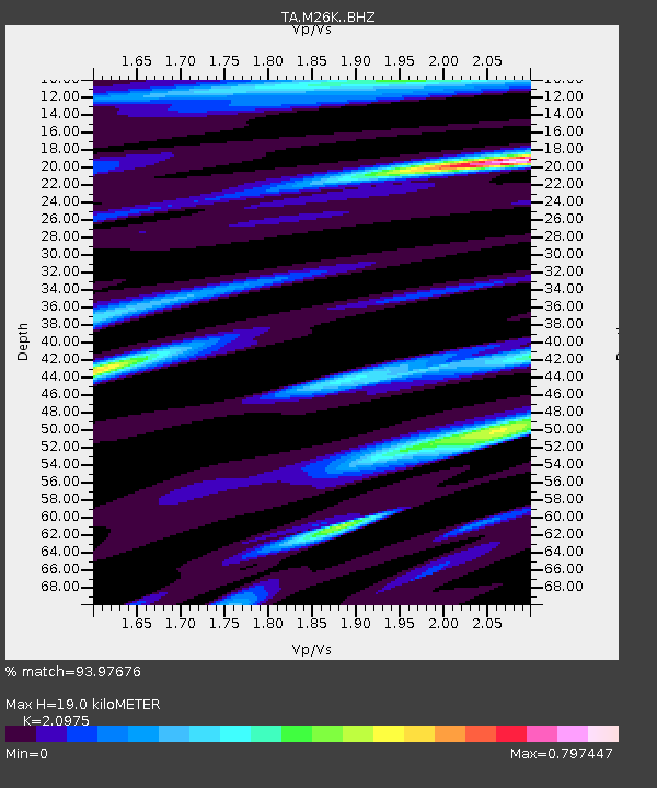
| Estimated Moho Depth: |
19.0 km |
| Estimated Crust Vp/Vs: |
2.10 |
| Assumed Crust Vp: |
6.566 km/s |
| Estimated Crust Vs: |
3.13 km/s |
| Estimated Crust Poisson's Ratio: |
0.35 |
|
| Radial Match: |
93.97676 % |
| Radial Bump: |
400 |
| Transverse Match: |
82.7998 % |
| Transverse Bump: |
400 |
| SOD ConfigId: |
7422571 |
| Insert Time: |
2019-04-22 07:15:31.392 +0000 |
| GWidth: |
2.5 |
| Max Bumps: |
400 |
| Tol: |
0.001 |
|

Signal To Noise
| Channel | StoN | STA | LTA |
| TA:M26K: :BHZ:20160415T16:34:40.575012Z | 9.841394 | 1.5311639E-6 | 1.5558403E-7 |
| TA:M26K: :BHN:20160415T16:34:40.575012Z | 2.0472713 | 2.092963E-7 | 1.0223184E-7 |
| TA:M26K: :BHE:20160415T16:34:40.575012Z | 7.322674 | 7.445039E-7 | 1.0167105E-7 |
| Arrivals |
| Ps | 3.3 SECOND |
| PpPs | 8.6 SECOND |
| PsPs/PpSs | 12 SECOND |


